


TRAIN 18 IN FULL THROTTLE SPEED AT 160 KM/hr
100
GATIMAN EXPRESS IN FULL THROTTLE SPEED OF 160 KM/hr
ROLL ON & ROLL OFF TRAINS
SPECIAL TRAINS
INDIA FIRST ELEVATED RAILWAY LAUNCHED IN ROTAK HARYANA
INDIAN FASTESR TRAINS IN FOG SEASONS
SPEED CHECKING IN DAY & NIGHT
NAXALS ATRACKS IN ODISSA , JHARKHAND , CHATTISGAD ON TRAINS
LIFE LINE TRAINS - RAILWAY COVID TRAINS & HOSPITAL TRAINS
REPUBLIC DAY TRAINS
DELHI TRAINS SHATABDI & TRAIN18 - All Express trains lead to DELHI
RAILWAY STATION & PLATFORMS - Agartals to bangalore trains at Badarpur station in Assam
FLOODED RAILWAY STATION
155 KM speed connect Delhi to Mumbai in 12 hrs from 16 hrs & Mumbai to Ahmedbad bullet train in 2 hrs time from 8 hours journey
TEA GARDEN Express - pride of people of both tamil nadu and kerala
 Tea Garden Express started in 1940 become the oldest train in kerala and pride of people of both tamil nadu and kerala
Tea Garden Express in 1940 from kochi port to ooty is the tea garden express to Karaikal with the same old name tea Garden . The overnight train from kochi to karikkal up/down is the pride of southern railway & kerala railway
Tea Garden Express from Ernakulam to karikkad one of the oldest train service from kerala
Ernakulam - Karaikal (Tea Garden) Express ( PT)/16188
16187 Karaikal - Ernakulam (Tea Garden) Express (PT) Route and Schedule.
Tea Garden history
The train introduced during the 1940s as Ooty–Cochin express to transport tea and related products from the Nilgiris to Cochin Port and further exported to Europe and world over. hence came the name of the train.
The train ran in meter gauge between Udhagamandalam and Mettupalayam and broad gauge between Mettupalayam and Cochin Harbour Terminus.
In Post Indian independence, the Ooty–Mettupalayam trip was cut–off and the train ran as No.565/566 between Cochin Harbour Terminus and Mettupalayam, since the 1970
Then, the Mettupalayam–Coimbatore Junction portion was cut–off and was re-routed to Tiruchirappalli Junction from Cochin (Ernakulam Junction), numbered as 6865 / 6866.
In the 2009–2010 Railway Budget, it was announced that the service will be extended to Nagore,[7][8][9] and the extension was effected on 30 March as Ernakulam - Karaikkal (Tea Garden) Express ( PT)/16188
16187 Karaikkal - Ernakulam (Tea Garden) Express (PT) Route and Schedule.
This train provides connectivity for the people of Kerala and western districts to educational institutions like Central University of Tamil Nadu, Thiruvarur, Thanjavur Medical College, JIPMER Karaikal and places of worship in delta districts, viz., Navagraha temples, Tirunallar Saniswaran Temple and Thyagaraja Temple, Tiruvarur others, Nagore Dargah and Velankanni Matha shrine.
Since this is oldest train the train runs very slow with crossing tome even to 2 hrs I trichinapalli and palakkad and delay upto 5 hrs
Other name of train that is very familiar are the Netravati Express , Mangala Exoress , Shalimar express ,
Engine direction change is making train delay-
Trichinapalli pally major station in TN is connecting trains to thanjavoor, chennai, erode and madurai direction. The railway station is in madurai track side making trains from chennai, thanjavoor to change engine direction to travel to erode as there is no line or station for trains to erode . This engine direction change is delaying trains .The viedio shows the Tea Garden Express train engine direction change.
https://youtu.be/iGqJ_NYRVtI
In trichinapalli town there is three station
1) Trichinapalli Junction station
2) Trichinapalli fort station
3) Trichinapalli town station
4) Tiruchirappalli Palakkarai railway station
5) Golden rock in thanjavoor line
6) Manjattidal in thanjavoor line
7) Tiruverumbur in thanjavoor line
8) Srirangam railway station
9 Uttamarkovil in chennai line
10 ) Pichchandarkovil in chennai line
11) Lalgudi in chennai line
In which trichinapalli junction station is main terminal and linking town station with junction station can avoid interchange of engine for trains to erode? Thanjavoor and erode direction as the junction railway is to madurai direction
Trichinapalli junction station trains engine direction is time consuming & this can be stopped by constructing a parallel railway from town station to junction station for trains in the direction of chennai / erode / thanjavur can can he linked by the parallel railway in red as in the maps & by this engine direction change in trichinapalli pally station can be stopped. In trichinapalli there us 11 station & connecting Junction & town station by new track can avoid engine direction change
The you tube vedieo shows engine direction change Karikkal express and Mysore express
Tea garden express / Karikkal express is from kochi to Karikkal and Mysore express is from Mayiladuthurai - kumbakonam - Trichinapalli - erode -coimbatore - bangalore and mysore
Tea garden express 2 hour halt in palghat and trichinapalli is due to the engine direction change of train as tea garden express from kochi is passing by trichinapalli junction railway station and palghat junction railway station that can be overcomed by the new railway line making railway not to change the engine direction
In trichinapalli T.N and palghat station kerala the trains had to change of engine and this was due railway station is opposite direction of track . By a new rail loop train can continue the journey by not changing direction of engine & the delay and time for engine direction change is nil . .In the kochi to Karikkal direction the tra is passing via trichinapalli & palghat junction , the down journey train passing town railway station not changing direction of engine make train fast
VENAD EXPRESS OF KERALA TO DOUBLE FLOOR 2021
 Kerala to own Venad express in double decker coach service and in five other passenger & express train service soon as railway had resumed operating in kerala after the covid breakdown . Railway after the covid breakdown is marginally increasing train service operation in kerala & soon will make all day running daily train service with double decker low floor coaches in Venad intercity express and other 5 day time trains in Kerala
Low floor double decker Rail service ( double decker )in kerala in venad intercity ecpress likely by 2021
Venad double decker express train after 40 years time
Kerala first intercity double decker coaches train discontinued in 1980 is soon going to be double decker LHB coached trains from 2021 after a gap of 40 year
In the 40 year gap Railway likely introducing double decker coaches in is to kerala own interciity trivandrum to shornur . Venad express of kerala discontinued the double decker service i in year 1980 is resuming again with new LHB double decker low floor coaches now soon
1980 venad with double decker coaches that was discontinued is likely to become double decker coach train in 2021 after a gap of 40 years , The double-decker coach is designed to travel at speeds of up to 160 km per hour as In case of accidents, LHB coaches would not pierce into one another. As the bogies are light they produce the least noise. It was also found that the LHB coaches can be run at a speed of 180km per hour.
The venad intercity express between trivandrum and shornur is likely to conduct services with double-decker coaches along with other 5 day time after tge covid breakdown
Venad, which started services in 1972, was the first double-decker train in Kerala during the 1980s. However, this was discontinued due to security reasons.
The coaches, however, were decommissioned in the early 1980s as passengers complained of suffocation and uneasiness. , but was running in westbengal in black diamond express train till 2000 year train accident and with LHB coaches development
“While those travelling in the upper deck felt hot and suffocated, those travelling in the lower deck suffered from inhaling dust entering through the lower deck windows situated almost at the ground level,” a senior railway official told The Hindu on Friday.
Kerala own Venad express 40 years before is a rail car is a two levels model passenger accommodation wagom made to increase the accomodation of passenger up to 57 % placing one coach over the other is not lower floor coaches is now going to be low floor LHB coaches that can accomodate more passengers st 160 km speed . The old low level two floor coaches that is up to levels of low bridges and tunnels was discontinued on not safe in kerala is now on two floor low floor double decker coached after 40 years gap
The venad old double decker was not low floor coaches with maxium speed up to 100 km made to increase passenger accomodation , but the new low floor coaches can travel at 160 km speed.
The time taken is almost 40 year to reshedule & bring back double decker low floor LHB coaches from old model that is not low floor coaches odd models tall enough to tilt & smash with the tunnel walls due to weight of coaches , breaking and speed making sparks and shaky while running against storm winds in opposite direction like a double decker buses that tilt in roads when winds blow from opposite direction.
In kerala Railway had resheduled 60 % of the express train service now that are in kerala railway line before covid pandemic and as Special trains Christmas holidays
The express trains in kerala that soon operating are
1 Kochuveli to Indore from Dec 12
2 Ernakulam to Oka special from Dec 11
3 kochuveli to Mysore from Dec 11
4 Vanchinad Express trivandrum to kochi From Dec14
5 Ernakulam to Kannur Intercity Express dec 15
6 Trivandrum to Mangalore ( Mangalapuram) dec 15
7 Trivandrum to Guruvayoor intercity Express dec15
8 Trivandrum to Madurai Amritha Express dec 23
SEMI HIGH SPEED BULLET TRAIN A IN KERALA STATE AS PASSENGER JOURNEY TRAIN FROM TRIVANDRUM KOCHUVEL TO KASARGOD 512 KM IN 5 HRS


SEMI HIGHSPEED RAILWAY PROJECT FROM KOCHUVELI TRIVANDRUM TO KASARGOD 512 KM IN 5 HRS
SEMI HIGH SPEED SILVERLINE CORRIDOR AND SUBURBAN RAILWAY
Silverline Semi High-speed Rail way from Kochuveli passing Paripally kollam at kundra , Bharanikavu , Charumoodu, Pandalam , Ala , Chengannur , Changanassery , Thiruvella at Eraviperrur , Puthupally , Kottayam at Manargad, Ettumanoor , Thalayolaparabu, Kakkanad , koch at kakkanad , Nedumbassery Airport , Thrissur , kunnamkulam , Parappanagadi , Mage, calicut , kannur and kasargod where tgere is Aligment changes and in other area parallel to old railway
GOD''S OWN COUNTRY RAILWAY IS EITHER THE SILVER LINE HSR CORRIDOR RAILWAY OR SUBURBAN SILVER LINE CORRIDOR RAILWAY THAT IS WORTH USEFUL AS NEW HSR RAILWAY IS CONTROVERSIAL POLITICALLY AND TECHNICALLY IN KERALA
MAPPING HSR SILVER LINE AND SUBURBAN SILVER LINE CORRIDOR RAILWAY as Railway differs from HSR silver line implementation technically and opposition party leaders and central goverment says the task and plan is not satisfactory as railway technically oppose now in the initial stage of planning
HSR Silver line corridor of kerala or is it suburban silver line rail corridor of kerala is worth useful when HSR silver line projects failed in the beginning itself
Designed to fail silver line corridor - kerala semi high speed railway corridor projects submitted is returned back by railway in planning stage itself says veteran congress men Shri Oomen chandi UDF leader kerala
Set back to semi highspeed railway Corridor projects in kerala where the funds are from France banks on short term loan period
Railway refuse to approve Kerala semi high speed railway Corridor plan from kasargod to trivandrum and the silence of Central government ministers to the projects is becoming a big hurdle & obstacle in implementing high speed railway Corridor in by kerala goverment LDF
Kerala opposition UDF leader Mr Oomen chandi on the occasion of 2020 tri plase election in December in kerala take up this matter in newsmedia that LDF goverment plan to implement highspeed railway is not approved by railway had appealed to LDF goverment to continue and complete the suburban railway corridor project started by UDF goverment rather than the Semi high speed railway on the point raised by railway where by suburban railway project completion can give top speed trains like Jan shatabdi , gatimqn cam speed up to 160 km per her slightly below to 200 km per he of semi speed railway Corridor
Semi highspeed railway survey done by hyderbad based company for 30 lacs by means of Lidar aerial mapping had submitted a survey reports that cost 120 crore per km is not acceptable to railway as they tell that this 120 crore may rise to 320 crore per km as the land value is higher in kerala may raise the cost of the projects to 1,60,000 crore ( 1lac 60 thousand crore ) from the estimate of 70000 crore jointly raised by central government and kerala is not acceptable to central government and railway as on kerala survey and estimated cost and revenue in return done by hyderbad base company on Lidar aerial maps and planning
Ommen chandi described that the subraban railway projects at 12000 crore from trivandrum to kasargod on changing alignment , doubling tracks from kochi to trivandrim & kochi to kasargod , changing the signal to automated signal in which kerala need to bear only 6000 crore and remaining 6000 crore by central goverment is affordable project than this lacs crore semi high speed railway that is not a planned one acquring large area of fertile and urban land
Ommen chandi UDF leader reminded goverment to verify the facts and upgrade the existing railway by means of suburban railway projects started by UDF goverment
The suburban railway corridor project can be developed to silver line corridor by ipdatomg the railway network , railway station, crossing , topography , alignments from trivandrum to kasargod via kochi rather than acquiring lands for new railway that is making the project safer and economics in many ways as today there are many high speed trains on wap engine , T 18 and Ascon
The Silver Line corridor intergrated with suburban and sabarimal railway will connect Thiruvananthapuram to Kasaragod through trains with operational speeds of 200 km per hour, covering the 529.45-km journey in four hours. These trains will cover the busy Thiruvananthapuram-Ernakulam stretch in 90 minutes, which at present takes more than four hours. Rather than for a seperate railway line parallel to present railway like of 530 Km
When compared to sabarimala railway and suburban Railway running parallel to present railway is upgrading , at present there will be lot of problems in acquiring lands for semi high speed railway and making a joint projects with center and france bank for semi high speed railway of millions of crore expense in lacs with out caring the interest of railway to sabarimala railway and suburban railway at present implemented by railway across nation and india with electric engine by converting disel to eletric or electro motive high speed engine of wap , Askon and T18/20.
In the Semi high speed railway Corridor where the only benefit on silver line I find other than speed is railway from trivandrum passing kollam , kundra / puthoor and connected till kottayam in seperate align ment passing via Pathanamthitta district from bharanikavu , , charumoodu , Pandalam , ala , chengannur in new station and going to kottayam , i at thiruvella passing via koeippuram which is a urban area parallel to oresent Thiruvella railway station , n kottayam passing via manargad in seperate railway alignment parallel to old railway passing puthupally , pala etc and in kochi the HSRC passing via kakkanad in seperate alignment not via north junction or south railway reaching Angamaly near nedumbassery airport connecting four airport of kerala trivandrim Airport , kochi , kozikode , kanni airport , from thrissur in seperate alignment via kunnamkulam parallel to ottapalam route meeting mahe and cslcuit connected by silver line in 4 hrs which can also be connected by suburban silver line railway in other ways with out this much project expense by means of new trains for airport and seperate alignment saving lot of revenue and for collecting more revenue to implement the pentomg projects of kerala railway ad per shri Oomen chandi the most veteran congress men and kerala UDF leader
As High-speed rail (HSR) is a type of rail transport that runs significantly faster than traditional rail traffic, using an integrated system of specialized rolling stock and dedicated tracks failed in survey and designing in kerala at 63000 crore when the railway calculation is on 160 lac crore , the suburban railway project next in kerala can be reformed to silver line HSR suburban railway projects seems worth useful now as railway is experiencing lot of difficult in acquiring land in kerala for sabarimala railway and suburban railwsy at this rate seems a major task ahead in completing HSR semi high speed railway silver line projects that is be implemented as suburban silver line projects when Semi high speed Rail corridor fails in inital stage of project planning, survey and project expense , acquring land etc and kerala goverment may take expert oppion for conducting this projects on joint hands with railway on suburban and sabarimala projects approved on 50 to 50 partnership
DESIGNED TO FAIL - K RAIL PROJECTS NEED RESURVEY AS RAILWAY DIFFERS IN DESIGN & ALIGNMENT
Railway dismisses the K - Railway alignment will make Kerala goverment to go ahead with this plan of K Railway from trivandrum to kasargod
Railway dismisses the K - Railway as expert suggest k- Railway Designed to fail project of CPIM like Nandigram as K- Railway extending outside kerala on Indian broadguage and inside on Seperate Alignments is raising doubts on Mutual benefits inside kerala as this kind of railway is not in tamil nafu and Karnataka to be connected like in kerala need more claruty to experts on how to balance and update tge project as Southern rakleau dismissed tHe project eben though kerala got silent aporpbal from central government
Broad guage Indian railway and highspeed railway Alignment in kerala by 2024 is two railway not one as railway blocking the alignment of K Railway Kerala Rail Development Corporation Ltd (KRDCL) raising objection on land acquring , project cost and people travelling
Two railway in kerala is not any where in another parts of India is hwving serious concerns about the ‘technologically unviable and capital-intensive project’.
Two railway one Indian railway amd other kerala High speed railway is leading to controversies & serious lapses in project management when southern railway is against this projects as this alignment of high speed railway may affect the expansion work of railway from kochi to kasargod as this Highspeed railway alignment is along the or parallel to broad guage line from kochi to kasargod and not object land acquring on the Broad guage lines as this may affect the expansion of india railway & clarify the project costis much beyond the estimated total that is low when the land value in kerala is higher and also raised doubts on the transportation of rails to the sites that is quite far from this present indian railway alignment as the weight of rails for this projects is higher and not easily transportable may increase cost.
This railway in kerala to be made one company rather than 2 and reduce the land acquring problems tgat make many homeless as the seperate alignments can reduce controversy and not to make nandigram in kerala as this railway in to two is not any where in india making both the railway to acquire land for construction and expansion will make many homeless and difficult to manage in terms of cost and expense at the same time with more difficulty
https://www.google.com/url?sa=t&source=web&rct=j&url=https://www.onmanorama.com/kerala/top-news/2021/01/10/kerala-silverline-project-southern-railway.amp.html&ved=2ahUKEwjWhcLixKHuAhUMyzgGHatTDV4QFjAAegQIARAB&usg=AOvVaw05Lyb1HqAkv4cGFLFoFWD8&cf=1

 CORRIDOR RAILWAY IN KERALA & K-RAILWAY SILVERLINE KERALA HIGH SPEED RAILWAY BY THE VANDEBHARATH TRAINS
  KOCHI , TRIVANDRUM , PALAKKAD, DIVISION RAILWAY IN KERALA FROM KANYAKUMARI TO KASARGOD , KANYAKUMARI TO COIMBATORE
(K-Rail)
SEMI HIGH SPEED RAILWAY KOCHI , TRIVANDRUM , CALICUT , PALAGHAT DIVISION RAILWAY IN KERALA FROM KANYAKUMARI TO KASARGOD , KANYAKUMARI TO COIMBATORE IN RED LINE FROM -KOCHUVELI TO KASARGOD
(K-Rail)
 CORRIDOR RAILWAY KOCHI TRIVANDRUM ,CALICUT ,PALAGHAT DIVISION RAILWAY IN KERALA FROM KANYAKUMARI TO KASARGOD , KANYAKUMARI TO COIMBATORE IN YELLOW LINE & RED IS THE NEW RAIL ALIGNMENT FOR SEMI HIGH SPEED RAILWAY
(K-Rail)
 SABARIMALA TRAIN FROM ANGAMALY TO ERUMELI
 SABARIMALA RAILWAY PROJECT
Plan to construct railway line to sabarimala will commence soon in kerala as kerala goverment agrees & pass the railway line work with railway on equal share
Kerala to share in the sabarimala railway line with railway connecting pathanamthitta , idukki in railway network as railway not willing to construct the railway line with out kerala equal partnership in the projects
[16/12, 15:59] Samuel Cherian: The Angamaly-Sabarimala rail project has got a new lease of life with Kerala agreeing to bear 50% of the estimate of ₹2,815.62 crore. ... The railway line, sanctioned in 1997-98, is one of the 10 stalled infrastructure projects of Southern Railway. The project was kept in abeyance by the Railways in December 2019.
Kerala goverment had the decision as per propsal of the railway submitted even after Modi recommendation
The total 111.20 km sabarimala railway from Angamaly to erumely passes by perumbavoor , kothamangalam , Muvattupuzha , Thodupizha , Ramapuram , Bharaniganam ( pala) , Kanjirapally, erumely of which railway had complwted only 7 km eailway from Agamaly to kalady 7 km thay was started in 1997
Kerala goverment had secided tl fund the project from fund collected from Kerala Infrastructure Investment Fund Board (KIIFB). .
The railway will do all the maintainence and working of this railway and remaing railway station and land acqusation is build and acquired by kerala goverment
The railway passing via many tunnels and bridges will connected to punaloor as to extend the railway to tamilnadu in kollam to chenkotta railway oassing via punaloor .
The time required for this 5 years , but can be constructed in 3 years time if done fast .
[16/12, 16:00] Samuel Cherian: The sabarimala railway and sabarimala Airport at erumeli will side by side make lot of development in kerala


SABARIMALA TRAIN FROM KOTTAYAM TO ERUMELI


 SABARIMALA TRAIN FROM KOLLAM- KOTTARAKARA TO ERUMELI
 VANDEBHARATH - Semi high speed trains at 160km/ h in India - MADE - IN - INDIA PROJECT

India semi high speed trains T18 is operating in two route now

 Semi high speed trains at 160km/ h in India - MADE - IN - INDIA PROJECT
India semi high speed trains T18 is operating in two route now
1) Delhi to Varnasi ( UTTAR PRADESH)
2) Delhi to Karta ( KASHMIR)
T18 is semi high speed engine less self propelling and had a maxium speed of 160 km per hr made of light weight coaches developed by india
The train was launched on 15 February 2019, by which date a second unit will have been produced and readied for service.The service was named 'Vande Bharat Express' on 27 January 2019 between delgi and Varanasi and second train wss on October 1 2019 on Navshivratri day As of July 2020, the Indian Railways operates two Vande Bharat trains
time taken is 6 hrs to delhi to Varanasi and 2 hrs to reach delhi to Kanpur
time taken is 8 hrs to delhi to Karta
Railway had not added any more T18 trains there after and said no more train18 for time being
The reason are
T18 self propelling engine less trains is not energy sufficient like other trains and india had no such energy distribution to conduct services of more trains of T18 at same time due to less energy support for large number of T18 trains and on the reason of accidents
But according to expert he train T18 is more energy sufficient than other shatabdi trains
As per simulations made at Integral Coach Factory (ICF) where Vande Bharat or Train 18 was made, the specific energy consumption (SEC) of gross ton km was 15.4 kWh lesser than other Indian speedy trains," a source not wanting to be identified told IANS.
As per the simulations done at the ICF, the specific energy consumption of Shatabdi Express was 17.2 kWh per gross ton km, the source added.
2 ) energy sufficient because Vande Bharat or Train 18 that runs of broad gauge has an axle load of less than 17 ton when compared to Shinkasen (300 kmph), Frecciarossa (300 kmph), and Chinese High Speed (300 kmph) all have axle load of 17 ton.
The Train-18 was built at a cost of about Rs 100 crore. that is 40 % cheaper than other trains
On 3 July 2014, a WAP-5 intercity express chair car set an Indian speed record by hauling a train from Delhi to Agra within 90 minutes at a speed of 160 km/h (99 mph). The Gatimaan Express and Bhopal Shatabdi trains hauled by WAP-5 locomotives travel at 160 km/h (99 mph) and 150 km/h (93 mph) respectively in the New Delhi - Agra
WAP 7 sleeper class long distance series engine will pull off a passenger train with 24 coaches at 140 km/hr speed, but this new engine: WAP-7HS ran at 160 km/hr speed, with 24 coaches. As per reports coming in, very soon, WAP-7HS will be deployed for Shatabdi and Rajdhani Express trains and Duronto as well.
New tejas series train are the Tejas Express locos for 'push-pull' operations with aerodynamically designed WAP-5 (loco no. 35012 & 35013). that had a speed of 160 km / h designed on aerodynamic coaches that is less air resistant in 24 coaches and had the stability at high speed on this two engine WAP-5 (loco no. 35012 & 35013).


 When compared to WAP series and T18 the delhi to lucknow WAP engine is slower than T18 delhi to Varanasi
In the railway network project on semi high speed time in kerala energy consumption, distribution, availability had to mee wuth tge rakes energy sufficiency and there requirement when two or three semi high speed trains of consume energy and support load had to maintained other wise similar sitwation may raise in kerala like in T18 trains service where no new trains can be added due rakes that are not energy sufficient and there is no support load when many trains service are conducted or increase the rakes


 NORTH EAST CORRIDOR RAILWAY OF INDIA
WEST BENGAL , ASSAM , SIKKIM , MEGALAYA , TRIPURA , NAGARLAND , MANIPUR


 North east Railway Broad guage connectivity in North east remote states & location and developing North east frontier railway is the Asian Railway line passing India -
Six of the eight north-eastern states' capital cities will come on the Indian railway map by March 2023, top railway officials said. The new railway lines were laid to extend the railway lines in three more capital cities of northeast India — Imphal (Manipur), Aizawl (Mizoram) and Kohima (Nagaland) — excluding Meghalaya’s Shillong and Sikkim’s Gangtok. and 8 states will ve having connectivity by next 5 years as per sources
India Broad guage railway will be Mizoram Capital Aizwal 2021 and by March 2023, Manipur, Mizoram and Nagaland to have rail connectivity
The North-east Frontier Railways (NFR), which has already connected Assam's main city Guwahati (adjoining capital Dispur), Tripura and Arunachal Pradesh's capital cities, is laying tracks to connect the capital cities of three more north-eastern states -- Manipur, Mizoram, Meghalya and Nagaland -- by March 2023.
It is true that from calcutta to Norrth eastern railway via Assam will be 1000 km more than railway by bangladesh to tripura and north eastern states and back , but north east railway is not from calcutta but from north India states like bihar , uttrarpradesh , Haryana and delhi via assam Guwahati
As of today, except Sikkim, all North-Eastern states are connected to the rail network. The capitals of Assam, Tripura and Arunachal Pradesh are already connected. In Manipur, Mizoram, Nagaland and Meghalaya, the capital connectivity work is in progress.or these states meter guage convertion to broad guage is in progress for cargo and passenger train by 2021 till capital of miziram and by 2023 to mizoram , nagarland and manipur
North east railway to Manipur
Jiribam-Imphal railway project: In the state of Manipur, the capital, Imphal to get Indian Railways connectivity through the 111 km long Jiribam-Imphal project. This railway project is likely to be completed by March 2022.
North east railway to Mizoram
Bhairabi Sairang railway project: In the state of Mizoram, the capital, Aizawl to get Indian Railways connectivity through the 51 km long Bhairabi Sairang project, which is expected to be completed by March 2023.
North east railway to Nagarland
Dimapur-Kohima railway project: In the state of Nagaland, the capital, Kohima to get the rail network through 82 km long Dimapur-Kohima project. This rail project is expected to be completed by the month of March 2023.
North east railway to Meghalaya
Teteliya-Byrnihat railway project: The capital of Meghalaya, Shillong will be connected to the Indian Railways network through the 22 km long Teteliya-Byrnihat project. This railway project is likely to be completed by March 2022.
North east railway to Sikkim
Sivok-Rangpo railway project: The capital of Sikkim, Gangtok will get Indian Railways connectivity through the 44 km long Sivok-Rangpo railway project..
The attached map shows that the long north east railway by Assam which is the back bone to these all north east states that extend till the borders of Assam at sonia bazar , dengeri , dibugraph and this railway is extended tp Aizwal of Mizoram .
Agarthal the capital of tripura is having tge hraod giage railway conbectivity by bangladesh rather than this Assam route reduces 1000 km from between Calcutta and trupura
North eastern states joining by railway and road via Assam started years before under the Narashima Rao goverment when India government takes crores of Rupees loan and aid from Asian bank to develop roads across river brahmaputra which is then as Asian highway road passing Assam valley to north eatern states to burma , malaysia. In that period taking huge loan from Asian Goverment was opposed by UDF coalition party saying huge loans gecome a burden of goverment even the longest bridge across Bhramaputra collapsed and rebuild , but the center goverment decision under Narashima Rao to joint all these north states by roads will unite these states to india rather than seperate countries was supported by Asian bank later giving lot of financial support to develop a Asian highway to north eastern countries via assam through these states which inturn benefitted india economy and unity in remote states in north eastern states
Like roads connectivity in india as Asian highway project in Narashima Rao goverment passing by North eastern states under Asian bank support , this north eastern railway connectivity in Narendra modi goverment will soon become Asian railway passing india through this states to other countries in future will benefit india economy and unification even though the projects need crore of rupees thay is returned back like roads if this projects is undertaken by asian bank for the development of Asia railway .
BULLET TRAIN PROJECT IN INDIA
BULLET TRAIN FROM MUMBAI TP AHMEDBAD

 Bullet Train - Shinkansen bullet trains at Mumbai to Ahmedabad Railway
Mumbai-Ahmedabad Bullet Train: Infrastructure behemoth Larsen & Toubro (L&T) has emerged as the lowest bidder at Rs 24,985 crore for constructing the 237.1 km under Package C4 of the 508.17 km Mumbai-Ahmedabad High-Speed Rail. This was one of the largest infrastructure tenders the country has seen.
Package C4 represents 46.66 per cent of the main-line making it the longest amongst all, and runs elevated from Zaroli Village on the Maharashtra – Gujarat border to Vadodara Station through 4 stations at Vapi, Bilimora, Surat and Bharuch in Gujarat.
This entire section is in Gujarat, where more than 83 per cent of the land has been acquired for the project.
This tender covers 46.66 per cent of total alignment of the 508 km long corridor, between Vapi and Vadodara in Gujarat, which includes four stations namely Surat, Vapi, Billimora and Bharuch, 24 river as well as 30 road crossings.
Mumbai to Ahmedabad bullet train is 508.17 km
Mumbai to vapi is 170
Vadodara to Ahmedabad is 101
Total is 271
Vapi to Vadodara L& T projects is 508.17 - 271 = 237.17 that is 46.33 of projected awarded at lowest bid of 25000 crore that is one of biggest tended projects in India by any company
https://youtu.be/V130j5l65ms
https://youtu.be/TfEWZNb_DUM


 HIGH SPEED BULLET TRAIN AS PASSENGER JOURNEY TRAIN AND 12000 HP TRAIN ENGINE FOR CARGO SERVICE RUNNING AT A SPEED OF 110 Km/H IN 6000 TON WEIGHT
 Navigation map of Indian railway attached in lines types and level is done by digitizing , attribution
 Connecting the railway in lines type , level
 RAILWAY AND ROAD NETWORK PASSING OUTSIDE TH MUMBAI CITY
 NEW RAILWAY LINE BETWEEN KOTTARAKARA AND CHENGANNUR PASSING ADOOR / PANDALAM FROM KOLLAM THENGASHI LINE AND JOINING SABARIMALA
 The navigation map : railway line as per the importance on different colors line type is attached along the mail
BALANCING OF THE NETWORK FROM RED , ORANGE, BLUE , GREY , PINK - GREEN LINE AND CONNECTING IN ONE MAP
- 1. The red line is the corridor railway with train speed from 200 km per hr
- The Corridor railway North East and North West extending from Delhi to Chennai and Delhi to Bangalore is Connecting the places : Newdelhi-----> Agra ----> Kanpur---> Lucknow----> Varnasi ----> Patna ----> Calcutta----> Bhubaneshwar ----> Vijayawada----> Chennai ----> Bangalore ----> Gundakal----> Wadi----> Pune----> Mumbai ----> Ahemdbad ----> Jaipur ----> Agra ----> New Delhi.
- 2. The Orange Red line or the yellow line connected with red line is with train speed 150 km per hr
- The Mumbai to Calcutta railway is connecting Mumbai ----> Jalgorn----> Nagpur----> Dura----> Raipur---> Rourkela----> Tata Nagar----> Calcutta and other line is Trivandrum top Jolarpetta connected to Corridor railway
- 3. The blue line connected to the red and orange line is with train speed 120 km per hr
- Mumbai to Kanpur from Mumbai ----> itarsi----> Jabalpur----> Katni-----> Allahabad----> Kanpur---- lucknow or Patna
- 4. The Black line connected the blue and orange is with train speed with 105 km per hr
- Chennai to coimbatore viat Madura
- 5. The Dark Violet is with train speed 100 km per hr
- Madurai to Kanyakumari
- 6. The Green line us with train speed 80 km per hr is the other railway connected to meter guage
******" Line type and level for the color******"*
Color Line type and leveling is done as per the map , old network , other sources and the entire network is balanced so that important railway geometry the railway map is developed .
- 1. Red line is type 1 and level 1
- 2. Orange Red line or the yellow line is type 2 and level 2
- 3. Blue line is type 3 and level 3
- 4. Black line is type 4 and level 4
- 5. Dark Violet is type 5 & level 5
- 6. Green line is type 6 & level 6
The more high speed trains run in red and orange Line and fares are higher
And more passenger trains runs in green line
The. Color in map shows navigation that gives linear itinerary and feasible route and people or traveler had to change trains to go to remote places from high speed trains to low speed trains : Below the map

 RAILWAY DATA BASE ERADIS AND ERAIL
ERADIS data base - European Railway Agency Database of inter operatability and safety .The data base shall ensure the information relevant of the safety and interoperability is used for the collection and publishing of safety and interoperabilty - reveland documents of railway in and with member states in Europe is accessible and transparent to all interested parties and stake holders in the railway even it is passenger or cargo service .
RAILWAY DATA BASE ERADIS AND ERAIL
ERADIS data base - European Railway Agency Database of inter operatability and safety .The data base shall ensure the information relevant of the safety and interoperability is used for the collection and publishing of safety and interoperabilty - reveland documents of railway in and with member states in Europe is accessible and transparent to all interested parties and stake holders in the railway even it is passenger or cargo service .
The organization of agents ERA who are applicant and manufactures registered is formed by European council of member states of Europe .
The ERADIS consist of data base that are declared on applicant manufacturer subsystems and constituents and later implement om the suitability of subsystems and constituents
1.Applicant or Manufacture data on subsystem and in constituents is declared and authorized after the data is verified for suitably
2.The data are processed by IM infrastructural manager, NSA National Safety Authority , Notified body NoBo , after TSI technical specification of interoperability
3. The Railway undertaking will publish the data among the member nations in council on quality reports .
is also a railway at a base of cargo trains and passenger trains like hauled trains and tourist trains and develop a journey plan as the train availability , This data base is with Train no , Train Number , Time , freight and other details .
Russia country had Russian ERADIS connected to member states like Ukraine .
In India there should be a database to connect the trains service in member States and other countries like Bangladesh and Pakistan where the trains and travelling from India , in future to China and Nepal and Nepal is connected China by projects in railway
Navigation data base is like this as shown in the attached image showing the exact location and track in which the train is moving , giving updated data to driver and community
The Image file attached shown the Aerial view of the train passing by means of Radar that is viewed both by the drivers of the train , the station master and workers in the Rail like rail guard and saving this data in central console for the processing works in the main office . The image file shows the arrival of the other train in the station and waiting for the running train to enter the station . This kind of Data can be connected by the Railway data base .
 The GIS digital tourism as a start up projects
Digital tourism is making a data base of tourist places in India in company name and connect this places with transporting companies like Buses, taxi , luxuries cars, trains, airline, boats , chartered flights , helicopter , and hospitality industries like hotels , motels , home stay , paying guests etc . As today GIS tourist maps are with roads railways , boundaries , the company tourist map is to entertain tourist by services and facilities in transporting company and hospitality companies
The GIS digital tourism as a start up projects
Digital tourism is making a data base of tourist places in India in company name and connect this places with transporting companies like Buses, taxi , luxuries cars, trains, airline, boats , chartered flights , helicopter , and hospitality industries like hotels , motels , home stay , paying guests etc . As today GIS tourist maps are with roads railways , boundaries , the company tourist map is to entertain tourist by services and facilities in transporting company and hospitality companies
Eg - if a tourist arriving in India will be touring India like entire India , south India, north India , middle India , eastern India or western India as a traveler had lot of choices , the company will give all choice as in google maps .
The company will give a feasible itinerary of fares and charges for tourist in the selected places by means of transport companies and service available in India with hospitality
The company will give a linear route map connecting the places in order and providing the transport industry facility to the traveler
The company will give a time of flight and benefit in using each transport industry facility
This all details the company can provide by collecting information of passenger coming to India from foreign tour companies, travel agencies of foreign countries
The company can give advertisement of transport industry and hospitality industry to the clients as foreign tour companies and foreign travel agencies and charge service charge from hospitality and travel transport companies in India
So the company get service charges from traveler , trip organizer by using the best GIS tourist data base in India and on other side will get advertisement charges from travel transport companies and hospitality industry
Topic - Integrating many or all train network navigation data base to a Single single digital data base and will show the entire railway network
Indian railway had introduced the GPS location of maps is called as SIMRAN year 2010 and the Indian railway is develop satellite railway maps with ISRO launching vehicles year 2013 .
the navigation maps will be more useful if the route covered by the railway is also high lighted with some other color , the passenger will know the position of the train or location as per the color change in the route can be done by layering . the speed of the train moving . here the passenger or the railway department on know the route of the trains and the location of the train if there is color difference in the area covered and area to be colored ,but will not know the traffic in the route and opposite side trains passing by or the next train in the after the train
If the entire railway network is merged with all trains navigation data base showing the train location one after the other moving in one route or different route or a part of the journey in one route and changes the direction in next stage of the journey with trains running in the opposite side tracks will give the correct details to the travellors , the drivers and the workers of the railway can improve the work of the railway .
MONITORING THE TRAIN BY TRAIN BY REMOTE SENSING DIGITAL MAPS
if all the trains can be tracked are digitized and integrate by means of a maps , the entire railway map will be visible to public that the number of trains running in a route and the route map of trains and crossing of trains and he opposite side train passing if the map is developed with all railway tracks and to show the train by maps track by track by integrating the entire railway network to digital maps between long distance trains , inter city trains , cargo trains , passenger trains
MONITORING TRAIN BY TRAIN BY DIGITAL MAPS
1. integrating the Railway track network maps,
2. the train network database From express and non express trains
3. The train network maps to with navigation route maps
4. the train location as per GPS
5. the train route covered and not covered area highlighting
6. the stations locations with stopping station and non stopping stations
7. the speed and variations in speed , the late trains
8. the weather ,
9. the tickets availability ,
10. the station stopping and station not stopping ,
11. the railway bridges , road- rail crossing ,river bridges ,
12. The Geometry of railway lines with curves , terrace railway, the elevations , the market area, level crossings
13. Integrating the signal lights for stopping , crossing and interchange tracks with sensors
14 . the end map will be a integrated maps digital connecting the entire railway station of India with all trains , with the time of flight , linear route mapping , feasible itinerary, with hotels and tourist places
15 time of flight can be compared with each trains if all trains data base is integrated to know which train is moving fast
16 linear route mapping - shows data to traveler to change trains in intermediate stops in his journey and continue the journey in the other train
17. Feasible itinerary- this data base with hotels details will give feasible itinerary
18 . One month railway data base to be displaced and single like a calendar on which trains and special trains are in each month so that traveler choose by the digital map by selecting the date
19 All national highway . Road network data , ferry , airline to the towns near to be added so that traveler can make feasible and linear itinerary by joining railway of entire train navigation and track network data to road, ferry , airlines .
20. Hospital , motels , tourist data base had to integrated
Railway Navigation Data Base , reduce the. communication gap
Railway Database is developed to give information and instruction to the Engine driver of the train in the digital navigation maps by means of the radar screen similar go like in the war plane and ship in the train engine to follow the integrated instruction and information given by the railway center office, station master in the route and the guard in the route in field work in the train route coding and decoding the integrated signal by means digital maps and data base describing the time of flight of the train journey , linear route mapping , itinerary that need to be updated in every railway crossing stops / halts or other stops that is not in the journey due to other railway traffic hit in peak hours , due to traffic in other tracks in the route or due to a special trains , passenger , cargo train crossing , repair work , weather hazards or due to any other accidents , such information can be coordinated by means of navigation data base as the train starting from Mumbai to Kerala will not be aware of the halts in the long route can be given prior before the journey by the driver by the data base
The radar screen will give updated route map for the driver from the. Center office, station master , and the railway guard who works in the tracks
The Digital navigation maps of the railway network will be based on the data like
1. Number of Railway tracks like single track, of more .
2. Connecting cross section , Scissor junction connection for track inter change
3. The Railway station
4. The bridges
5. The curves
6. Railway elevation angle
7. The km distance between stations
8. Time of flight in the journey is the time taken to travel between origin and destination in a particular speed
9. Speed of the train
11 linear route mapping is made as per the itineraries or intermediates halts given as per the request of the station master and guard
12 primary data and maps is given by railway center office and secondary data are given by station master and guard in the route where the trains stops as intermediate station or halts
10 Villages, town the train is passing etc
11. Data are shown railway route network maps in the radar screen as per the geometry of the railway in lines, texts in single tracks or in dual tracks in tracks inter change as per the instruction given by center office , station , guard in the site
12. The center office will give the primary instruction and information in route of the train journey in single or multiple tracks due to tracks interchange from station to station with time of flight , speed , curves , bridges , elevation , crossing , level. Crossing , streets, traffic in the traffic in both directions landscape, forest , weather.giving the primary time of flight of journey , linear route mapping and itinerary
13. The station master give the secondary instructions via navigation map of the work area in the route in his area , the crossing of trains in the route other than the center office , weather information or any hazards in his range area that changes the primary information in linear route mapping time of journey and itinerary as per the station master request if there is any halts due to maintenance and crossing
14. The guard in the track give secondary data that changes the primary data in signal by signal lights if there is any dead end in the tracks in his route , track interchanges , crossing of train for stop in signal lights , these signal lights are captured by sensor in the train and sensed signal is decoded and displayed in window screen of the radar monitor other than the station master and the center office signal .
15. All the signals are via satellite to the radar monitor other than the sensed signal sent by the guard due to automated signals
16. If a train is stopping three or times due to other trains delays , or work in tracks while in the route , the software will update the primary data with the secondary data automatically on the data given by station master and guard in the route and the secondary instruction and information will be passed to the radar of the train regarding the stops and crossing part of journey and the driver can change the speed to overcome the delay by the updated map given and where to increase the speed can be checked by maps or can ask assistance from center office to the secondary data received . and such stopping in the route can give the exact time of flight of journey to the passenger and train driver before the commencements of journey . as this stops are not known before the journey , the exact time of flight of the journey is not correctly calculated as the person who charts will not know the exact number of stops and crossing in the journey and can be done by the navigation device
All such data are necessary for the railway data base. If this data are necessary , this data base is developed by
1. Digitization of maps with the complete number of tracks in both directions with cross section connection and scissor connection between tracks
2. Digitizing the resource in the map like bridges , rivers, crossing , tunnels, track elevation where all these can reduce the speed and increase the journey time as resources in maps is important
3. Curves
4. Attributing with codes and text
5. Location of station
This digitized line are will show the direction , gauge change, track interchange locations , stops, the sensed data from the sensor , and other device signals will improve the accuracy of information and these signals can be cross examined by person or officer in different offices as this digital maps are visible to all using the database
If this kind of radar screen are in planes and ships this can be added to the railway and giving accurate information to the driver and driver and co driver need not had to spend time and concentrate in work as they can interact more via the digital maps to center office, the station master and guard
Today most of GIS works are based on remote sensing and image processing , railway data base and remote sensing can be developed by integrating different layer maps together like integrating railway with different layer contour maps to show the inclination of the land an height different and the steep hills on the sides of tracks . such updation can be useful to check the intensity of a accident if the train running in in lines surface suddenly disappear as it falls in a deep pit of smash on the hill on the side tracks . All this integration can develop a compete data base
This data base will reduce the communication gap between the driver and the person who monitor the train journey and the person who monitor can interact more accurately to the engine driver , the men in field like station master and rail guard who take control of the train journey as the train enters to their territory and person who monitor the traffic in the route can verify or ask for report from the ground levels changing the journey and check these instruction from.station master or guard is correct or wrong and stop them to change the rules as per there wishes that make 2 hrs of more delay in one halts

Networking the impacts of Railway
Accidents of India -the express train accident in pukarayan connecting indore
and kanpur
Subject: Railway become a weapon of destruction that is unstable ,
Network Railway
accident
The Run Away Train - The Vision &
Mission of railway is dangerous due to the rising accidents -
The failure in
the reforms makes life Up side down
When the people of Bihar travel on the roof of the trains , the dragging the railway line doubling and tribiling of tracks are done with shortage of labour , machines and not consider the needs of people had resulted such accidents and making the life of people up side down, when more labour and machines are required for work , the railway negligence is the results of such accidents and death
The Inter state express train connecting Maharastra and Bihar state Derailment in uttarpradesh close to pukarayan railway station near to kanpur in Bihar accident had raised death toll to 142 disrupting the railway service to Bihar in this route
As most of trains connecting bihar is are with more passengers and result in heavy traffic made the people to travel on the roof of trains to Bihar and back . this accident in major route will affect the Bihar rail transport network and normal life , rescue work done on the 14 compartment is in progress due to more casualty due derailment . Every year lot of accidents world and there are similarity in accident world wide , the similar accident are like this when the coaches are up side down had raised the number of death even higher on speed and the causality and death is less due to low speed than euro rail . this kind of accidents had resulted in making common man life up side down.
Japense and Spain Bullet train
accident is similar to this accident
The Similarly is the accident took in
the edges of the curves
This accident is in a remote
place border UttarPradesh and Bihar and the accident had happen near a
curve .The photo images of accident shows that the compartments derailed are
the 14 compartment near the curve and after passing the curve. Reducing the
curves in the tracks
The railway accident between the
Indore and kanpur railway line had happened due to the following reason
GPS and GIS Navigation system for the
train driver with Digital maps (2) . Anti Collision Device Operating with the
Support of Transport Navigation satellite launched
Passenger life can be saved if emergency
exit and safety devices in trains work with more adaptability like in planes
the emergency exit are doors with skating air bags to floor and in
trains emergency is the small window opened locked and jammed due to rusting ,
there is inconvenience by emergency exit as people had to jump from small
emergency exit and other reason that can reduce accident
Most of railway accident is
happening in night , and railway security should be increased by modern
machines and light equipment
Speed Breaking in the rail curves can
cause wear and tear in tracks , steps to be taken to reduce braking and reduce
the railway line cracks
Over loading a train with no proper
suspension supports etc
GPS and GIS navigation system for
railway as a part of navigation satellites if there is no navigation satellite
support , implement it
Reduce the speed of the train in curves
and by using digital maps alert the driver while passing the curves and
can control speed
Modernization with electronic maps and
GPS navigation system for trains supported in the engine cabin is necessary to
alert the driver by maps on crossing bridges , curves . level crossing ,
crowded areas , station , now the engine driver is driving the train with
a steering , brakes , and window to view the signal and tracks , and the voice
mobile to receive and sent messages to communicate with station master should
be given digital navigation system in GIS and GPS to show the route map of
places and rail via maps
Anti collision device are necessary GIS
and GPS control
Emergency automatic doors with Air bags
to exit
Automatic doors, sleeper curtains ,
seat beats , good toilet and wash basin
Baby
berth for the safety of baby below 3 years and for the mother who feed
the baby , and ma-mooting babies is difficult in open berth , so
every berth should need curtains for privacy
Trolleys for luggage movement ,
security at railway station gate , railway station exit and entrance
guarded with aerial camera and security men , railway station facilities should
adapt for the long distance train stops .
Railway should ensure more safety
devices
Kerala state railway accident
on scanning shows more errors

Tree uprooted and fallen on railway track in kollam to Thenkasi Broad guage line between kuri and Avanishwaram station .
As the train time in between Twp station is 7 minutes , the train had not in full speed had made the train to stop in time as the driver saw this even this spot is in curve . The train stop due to emergency brakes and made the train to stop on hitting the tree across the tracks .


 Preventive steps are necessary , In
Kerala the Railway accident near to Angamaly where the derailed train coming from
banglore to kerala passenger life is saved as the other track train is stopped for
the train passing and crossing in the station rather than outside the station
.The decision taken by the station master is appreciated , but there is
some thing smelling bad due to errors and the on the decision taken by station
master , what had made him to stop the other track train in his station for the
passing and crossing of the derailed train in the station rather than outside
as the tracks are doubled .The errors can be
Preventive steps are necessary , In
Kerala the Railway accident near to Angamaly where the derailed train coming from
banglore to kerala passenger life is saved as the other track train is stopped for
the train passing and crossing in the station rather than outside the station
.The decision taken by the station master is appreciated , but there is
some thing smelling bad due to errors and the on the decision taken by station
master , what had made him to stop the other track train in his station for the
passing and crossing of the derailed train in the station rather than outside
as the tracks are doubled .The errors can be

The errors in
railway network for replacing he old tracks and daily check reports had
to compared to know the reason of the accidents
The station Master had changed the
rule of a double track railway line by stopping the train in the station
to make the crossing in the station as in doubling track there is no need to
make the crossing inside a station . This changing of rule in a double
track similar to a single track railway line is not proper in a
busy railway line .
As this decision of station master become public in a
railway accidents where the derailed train that lean to the other railway track
will create more damage if the other track train that is stopped in
station if not stopped may run over the derailed Bangalore express . his
decision was life saving this time , but the railway had to notice
those officers who changes the rules of the railway periodically
according there wishes troubling the public with hours of delay in the journey
when railway had spent crores of rupee on doubling of tracks
In India the road network jams
and blocks are increasing every year due to no parking space in
cities , no exit by pass roads making buses , trucks and cars to get stuck by
the jams and blocks . the exit by pass roads need to build , but not construct
by pass roads even in worst crisis even if the road density rises
on number of vehicles with time with in city town , village expansion resulting lot of accident in Kerala in Sabarimala and rainy season
Kollam to Thenkasi Broad guage line at Mylom crossing near kottarakara


Bhubaneshwar in orissa Railway accidents on Jan 23 2016


CHINA RAILWAY TO UK AND AND SPAIN FOR CARGO TRANSPORT
 Corridor railway to North. South. East, west
Travel across India by the corridor railway that extends from kanyakumsri to Jammu by the western railway via mumbai and return by eastern railway via chennai
There are many trains like Shathabi express , Rajadhani express duronto express , gatimaan express of which Bhopal Shatabdi Express. And gatimaan are the highest speed of 150 to 160/kmper hour


LINK OF PROJECTS ;
http://www.giscareers.com/CvDetail.aspx?CvId=8927
http://www.giscareers.com/CvDetail.aspx?CvId=12689
Railway Data Base
http://2017railway.blogspot.in/
Rubber Data Base
http://2017rubber.blogspot.in/
Tourism Data Base
http://2014keralatourisambook.blogspot.in/
Tourisam Data Base
:http://webber11.blogspot.in
Tourisam Data Base
: http://2014sabarimala.blogspot.in
Census Data Base
http://2015indiapopulation.blogspot.in
Census Data Base
http://2014censusdata.blogspot.in/
Navigation Map Data Base
http://2016navigator.blogspot.in/
Navigation Map Data Base
http://2015gis.blogspot.in/
Resume URL
http://www.georgiescherian.yolasite.com
GIS Maps QA (navigation)
Navigation Map Project in and data India Pune and Edgemapgis Bangalore for 5 year
The Project is based on European road network Topo 1:200 K and Marcopolo 1:250K
The Software is Neteditor Route Map Software and Mapeditor and layout &
Index in Mapderivator
The Countries and Map in the Projects
1.GermanyPoland, Spain, Finland, Italy, Netherland, Bulgaria, Czechoslovak
2.Slovenia, Romanian, Greece, Bulgaria, Russia, Australia
3.Azerbaijan;, Ukraine, Turkey , Philippines, Indonesia, Sweden
4.Angola, Madagascar, Ivory coast, Libya, Algeria, Morocco, Mexico
5.Peru, Argentina, Paraguay , Yugoslavia, SwitzerlandColumbia
Quality work in the production of Navigation map
Quality work of the map is making the productivity grade of the digitized to 100% and that is very important in navigation map so that correct data can be given be the beneficiary or the customer
The Task of the Quality check process in the Navigation map and they are as follows and depend sources and data given with work instruction :
1. Checking of the maps is done with Geometry Correction of the digitized map and is doen by Accurate by shaping of te digitized lines , slip road geometry, etc and digitized line should be along the scanned map casing and done by visual check or grid wise checks
2. Dead End in the digitized lines and is corrected on the connectivity of the lines as per the map sources and the side maps
3. Missing roads can be corrected by digitizing all the resources and roads in the map mainly in the city maps that is with other scale size
4. Line type Errors can be corrected by Digitizing the map with correct line types, thickness and colour and correct type are given like Motor highway with red and blue line , Dual carriage roads with line in the middle ,trunk highway with large yellow line and province highway with narrow yellow line and brown and white other roads can be given correctly by giving the correct line type
4(a) : Direction of the roads had to be correct even if there is slip road geometry with correct types and level with highway
5. Level correction : The correct level is given each type segment so that map can be more visible
6. Old network data matching . All the data in the old network digital map had to given while digitizing , if any data in the old network are not in the scanned map or other sources , the data in old network had to be given in the new map
7.Crossing of roads . Crossing of roads and rails given with correct over pass and underpass , the data should not be incorrect while doing work with floor codes
8.. Adding slip roads , flyover, roundabout , lay bye, bridges , had to be given in the map when there is a cluster of road meeting at a point .
9. Balancing of Network : Balancing of the network is necessary with the side maps as there will be change in type and level when the town expands or the province expands with other roads . So next top levelling and type adjustment of segments had to be made on balancing of the network mainly in the highway
10. Adding Imaginary roads . : Adding Imaginary roads is necessary if a town or village in the map is not connected with a national highway passing near by .
11. Attribution and Text : Attributing all the cities , towns , villages , road names , in the map with first name and second with correct type and levels , where all the sources are required to mark all roads and town names with correct spelling and special characters .
12 : Road Naming : Adding first name and second name to segments for roads name is done done first names and codes of slip roads tunnels are entered in second
13 Tunnel : Tunnels in the maps are entered with line type and level with signs and with second name codes
14. Text correction : Correct spelling of text had to entered and there will not be any overlapping between text and between roads
15. overlapping : Overlapping in the road and boundary network had to checked and overlapping of data to be reduced
16 : Checking the intersection at junction with correct geometry
17 . Ferry and Airline data : All ferry and airline line with types and level had to be entered in the map with route direction
18. Merging of map with map edge correction by connecting all the dead ends at the boundary of the map with next maps
20 Railway network : correct type and level to be given all railway tracks in map with different line type with station
21 , All map symbols , tourist places , had to be marked .
22 : All sealed and unsealed roads with roads under construction with construction period had to be entered
23. City roads had to entered from 1: 50 k city maps and city inserts for correct data types and levels .
24. Polygon in maps : are givers, islands, forest are, beaches , with point attribution with city polygons
25 . Boundary network : Boundary network should be with all rivers, lakes, reservoir , islands boundary, state boundary , coastline, forest area, in correct geometry , types and levels and overlapping had to be removed with Road and Boundary network are joined with correct geometry while merging
26 Image editing in the aerial maps are done removing the cracks and white spots in the map . Image editing is done when images overlapping and the edges of the image map with not connect with the next maps edges .
27 Street address data base . : The Correct address of places with P.O Box number are given as per the street address data base with respect to the GPS Longitude and latitude .
28 : Google Aerial Maps : Are used to check the Aerial data base of places with elevation
29 : UP and down in Road s: Road Elevation had to given along the road if the roads had steep mountains while in the route .
30. Bridges had to be given even if this a small culvert :
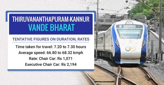
New Vandebharath express trains for kerala year 2023
Vandebharath T18 Train Delight : 3 New trains in kerala for year 2023
A/C, Non A/C , S/L Coaches in 2023 vandebharath kerala Express -
Vande Bharat makes surprise entry in Kerala,
Trivandrum to Kasaragod Vande Bharat Express Timing
(20634) The Vande Bharat Express train runs between Trivandrum Central (TVC) to Kasaragod (KGQ). The 20634 Vande Bharat Express train leaves Trivandrum Central at 05:15 hours and reaches KGQ station at 13:20 hours on the 1st day of departure. The cover the distance in 8 hours time
The Vandebharath train from kochi to Bangalore will start at Bengaluru by 4am to Ernakulam on a Friday. The train will reach Ernakulam junction at 1.30pm and it will return by 2 pm. By 10pm, on the same day, the train will reach Bengaluru. the train covers the distance in 9 hours time
The vandebharath had reduced the time require in trivandrum to kasargod 570 km in 8 hrs from 9 to 15 hrs in different express train time and in the Kochi to bangalore from 12 + hrs to 9 hrs is very fast and will be more faster once the railws are levelled in kerala with less curves and bends
The Train is useful for marriage function trips , business trip , tour package trip or hospital emergency trips purpose in kerala and many had benefit of this train trip daily . Marriage can be arranged according to the train trips as the bride or groom & family can comfortably reach the function places as the train reaches early in metro cities of kerala and even to airports and ports


End
 |
 |

TRAIN 18 IN FULL THROTTLE SPEED AT 160 KM/hr
100
GATIMAN EXPRESS IN FULL THROTTLE SPEED OF 160 KM/hr
ROLL ON & ROLL OFF TRAINS
SPECIAL TRAINS
INDIA FIRST ELEVATED RAILWAY LAUNCHED IN ROTAK HARYANA
INDIAN FASTESR TRAINS IN FOG SEASONS
SPEED CHECKING IN DAY & NIGHT
NAXALS ATRACKS IN ODISSA , JHARKHAND , CHATTISGAD ON TRAINS
LIFE LINE TRAINS - RAILWAY COVID TRAINS & HOSPITAL TRAINS
REPUBLIC DAY TRAINS
DELHI TRAINS SHATABDI & TRAIN18 - All Express trains lead to DELHI
RAILWAY STATION & PLATFORMS - Agartals to bangalore trains at Badarpur station in Assam
FLOODED RAILWAY STATION
155 KM speed connect Delhi to Mumbai in 12 hrs from 16 hrs & Mumbai to Ahmedbad bullet train in 2 hrs time from 8 hours journey
TEA GARDEN Express - pride of people of both tamil nadu and kerala

Tea Garden Express started in 1940 become the oldest train in kerala and pride of people of both tamil nadu and kerala
Tea Garden Express in 1940 from kochi port to ooty is the tea garden express to Karaikal with the same old name tea Garden . The overnight train from kochi to karikkal up/down is the pride of southern railway & kerala railway
Tea Garden Express from Ernakulam to karikkad one of the oldest train service from kerala
Ernakulam - Karaikal (Tea Garden) Express ( PT)/16188
16187 Karaikal - Ernakulam (Tea Garden) Express (PT) Route and Schedule.
Tea Garden history
The train introduced during the 1940s as Ooty–Cochin express to transport tea and related products from the Nilgiris to Cochin Port and further exported to Europe and world over. hence came the name of the train.
The train ran in meter gauge between Udhagamandalam and Mettupalayam and broad gauge between Mettupalayam and Cochin Harbour Terminus.
In Post Indian independence, the Ooty–Mettupalayam trip was cut–off and the train ran as No.565/566 between Cochin Harbour Terminus and Mettupalayam, since the 1970
Then, the Mettupalayam–Coimbatore Junction portion was cut–off and was re-routed to Tiruchirappalli Junction from Cochin (Ernakulam Junction), numbered as 6865 / 6866.
In the 2009–2010 Railway Budget, it was announced that the service will be extended to Nagore,[7][8][9] and the extension was effected on 30 March as Ernakulam - Karaikkal (Tea Garden) Express ( PT)/16188
16187 Karaikkal - Ernakulam (Tea Garden) Express (PT) Route and Schedule.
This train provides connectivity for the people of Kerala and western districts to educational institutions like Central University of Tamil Nadu, Thiruvarur, Thanjavur Medical College, JIPMER Karaikal and places of worship in delta districts, viz., Navagraha temples, Tirunallar Saniswaran Temple and Thyagaraja Temple, Tiruvarur others, Nagore Dargah and Velankanni Matha shrine.
Since this is oldest train the train runs very slow with crossing tome even to 2 hrs I trichinapalli and palakkad and delay upto 5 hrs
Other name of train that is very familiar are the Netravati Express , Mangala Exoress , Shalimar express ,
Engine direction change is making train delay-
Trichinapalli pally major station in TN is connecting trains to thanjavoor, chennai, erode and madurai direction. The railway station is in madurai track side making trains from chennai, thanjavoor to change engine direction to travel to erode as there is no line or station for trains to erode . This engine direction change is delaying trains .The viedio shows the Tea Garden Express train engine direction change.
https://youtu.be/iGqJ_NYRVtI
In trichinapalli town there is three station
1) Trichinapalli Junction station
2) Trichinapalli fort station
3) Trichinapalli town station
4) Tiruchirappalli Palakkarai railway station
5) Golden rock in thanjavoor line
6) Manjattidal in thanjavoor line
7) Tiruverumbur in thanjavoor line
8) Srirangam railway station
9 Uttamarkovil in chennai line
10 ) Pichchandarkovil in chennai line
11) Lalgudi in chennai line
In which trichinapalli junction station is main terminal and linking town station with junction station can avoid interchange of engine for trains to erode? Thanjavoor and erode direction as the junction railway is to madurai direction
Trichinapalli junction station trains engine direction is time consuming & this can be stopped by constructing a parallel railway from town station to junction station for trains in the direction of chennai / erode / thanjavur can can he linked by the parallel railway in red as in the maps & by this engine direction change in trichinapalli pally station can be stopped. In trichinapalli there us 11 station & connecting Junction & town station by new track can avoid engine direction change
The you tube vedieo shows engine direction change Karikkal express and Mysore express
Tea garden express / Karikkal express is from kochi to Karikkal and Mysore express is from Mayiladuthurai - kumbakonam - Trichinapalli - erode -coimbatore - bangalore and mysore
Tea garden express 2 hour halt in palghat and trichinapalli is due to the engine direction change of train as tea garden express from kochi is passing by trichinapalli junction railway station and palghat junction railway station that can be overcomed by the new railway line making railway not to change the engine direction
In trichinapalli T.N and palghat station kerala the trains had to change of engine and this was due railway station is opposite direction of track . By a new rail loop train can continue the journey by not changing direction of engine & the delay and time for engine direction change is nil . .In the kochi to Karikkal direction the tra is passing via trichinapalli & palghat junction , the down journey train passing town railway station not changing direction of engine make train fast
VENAD EXPRESS OF KERALA TO DOUBLE FLOOR 2021

Kerala to own Venad express in double decker coach service and in five other passenger & express train service soon as railway had resumed operating in kerala after the covid breakdown . Railway after the covid breakdown is marginally increasing train service operation in kerala & soon will make all day running daily train service with double decker low floor coaches in Venad intercity express and other 5 day time trains in Kerala
Low floor double decker Rail service ( double decker )in kerala in venad intercity ecpress likely by 2021
Venad double decker express train after 40 years time
Kerala first intercity double decker coaches train discontinued in 1980 is soon going to be double decker LHB coached trains from 2021 after a gap of 40 year
In the 40 year gap Railway likely introducing double decker coaches in is to kerala own interciity trivandrum to shornur . Venad express of kerala discontinued the double decker service i in year 1980 is resuming again with new LHB double decker low floor coaches now soon
1980 venad with double decker coaches that was discontinued is likely to become double decker coach train in 2021 after a gap of 40 years , The double-decker coach is designed to travel at speeds of up to 160 km per hour as In case of accidents, LHB coaches would not pierce into one another. As the bogies are light they produce the least noise. It was also found that the LHB coaches can be run at a speed of 180km per hour.
The venad intercity express between trivandrum and shornur is likely to conduct services with double-decker coaches along with other 5 day time after tge covid breakdown
Venad, which started services in 1972, was the first double-decker train in Kerala during the 1980s. However, this was discontinued due to security reasons.
The coaches, however, were decommissioned in the early 1980s as passengers complained of suffocation and uneasiness. , but was running in westbengal in black diamond express train till 2000 year train accident and with LHB coaches development
“While those travelling in the upper deck felt hot and suffocated, those travelling in the lower deck suffered from inhaling dust entering through the lower deck windows situated almost at the ground level,” a senior railway official told The Hindu on Friday.
Kerala own Venad express 40 years before is a rail car is a two levels model passenger accommodation wagom made to increase the accomodation of passenger up to 57 % placing one coach over the other is not lower floor coaches is now going to be low floor LHB coaches that can accomodate more passengers st 160 km speed . The old low level two floor coaches that is up to levels of low bridges and tunnels was discontinued on not safe in kerala is now on two floor low floor double decker coached after 40 years gap
The venad old double decker was not low floor coaches with maxium speed up to 100 km made to increase passenger accomodation , but the new low floor coaches can travel at 160 km speed.
The time taken is almost 40 year to reshedule & bring back double decker low floor LHB coaches from old model that is not low floor coaches odd models tall enough to tilt & smash with the tunnel walls due to weight of coaches , breaking and speed making sparks and shaky while running against storm winds in opposite direction like a double decker buses that tilt in roads when winds blow from opposite direction.
In kerala Railway had resheduled 60 % of the express train service now that are in kerala railway line before covid pandemic and as Special trains Christmas holidays
The express trains in kerala that soon operating are
1 Kochuveli to Indore from Dec 12
2 Ernakulam to Oka special from Dec 11
3 kochuveli to Mysore from Dec 11
4 Vanchinad Express trivandrum to kochi From Dec14
5 Ernakulam to Kannur Intercity Express dec 15
6 Trivandrum to Mangalore ( Mangalapuram) dec 15
7 Trivandrum to Guruvayoor intercity Express dec15
8 Trivandrum to Madurai Amritha Express dec 23
SEMI HIGH SPEED BULLET TRAIN A IN KERALA STATE AS PASSENGER JOURNEY TRAIN FROM TRIVANDRUM KOCHUVEL TO KASARGOD 512 KM IN 5 HRS


SEMI HIGHSPEED RAILWAY PROJECT FROM KOCHUVELI TRIVANDRUM TO KASARGOD 512 KM IN 5 HRS
SEMI HIGH SPEED SILVERLINE CORRIDOR AND SUBURBAN RAILWAY
SEMI HIGH SPEED SILVERLINE CORRIDOR AND SUBURBAN RAILWAY
Silverline Semi High-speed Rail way from Kochuveli passing Paripally kollam at kundra , Bharanikavu , Charumoodu, Pandalam , Ala , Chengannur , Changanassery , Thiruvella at Eraviperrur , Puthupally , Kottayam at Manargad, Ettumanoor , Thalayolaparabu, Kakkanad , koch at kakkanad , Nedumbassery Airport , Thrissur , kunnamkulam , Parappanagadi , Mage, calicut , kannur and kasargod where tgere is Aligment changes and in other area parallel to old railway
GOD''S OWN COUNTRY RAILWAY IS EITHER THE SILVER LINE HSR CORRIDOR RAILWAY OR SUBURBAN SILVER LINE CORRIDOR RAILWAY THAT IS WORTH USEFUL AS NEW HSR RAILWAY IS CONTROVERSIAL POLITICALLY AND TECHNICALLY IN KERALA
MAPPING HSR SILVER LINE AND SUBURBAN SILVER LINE CORRIDOR RAILWAY as Railway differs from HSR silver line implementation technically and opposition party leaders and central goverment says the task and plan is not satisfactory as railway technically oppose now in the initial stage of planning
HSR Silver line corridor of kerala or is it suburban silver line rail corridor of kerala is worth useful when HSR silver line projects failed in the beginning itself
Designed to fail silver line corridor - kerala semi high speed railway corridor projects submitted is returned back by railway in planning stage itself says veteran congress men Shri Oomen chandi UDF leader kerala
Set back to semi highspeed railway Corridor projects in kerala where the funds are from France banks on short term loan period
Railway refuse to approve Kerala semi high speed railway Corridor plan from kasargod to trivandrum and the silence of Central government ministers to the projects is becoming a big hurdle & obstacle in implementing high speed railway Corridor in by kerala goverment LDF
Kerala opposition UDF leader Mr Oomen chandi on the occasion of 2020 tri plase election in December in kerala take up this matter in newsmedia that LDF goverment plan to implement highspeed railway is not approved by railway had appealed to LDF goverment to continue and complete the suburban railway corridor project started by UDF goverment rather than the Semi high speed railway on the point raised by railway where by suburban railway project completion can give top speed trains like Jan shatabdi , gatimqn cam speed up to 160 km per her slightly below to 200 km per he of semi speed railway Corridor
Semi highspeed railway survey done by hyderbad based company for 30 lacs by means of Lidar aerial mapping had submitted a survey reports that cost 120 crore per km is not acceptable to railway as they tell that this 120 crore may rise to 320 crore per km as the land value is higher in kerala may raise the cost of the projects to 1,60,000 crore ( 1lac 60 thousand crore ) from the estimate of 70000 crore jointly raised by central government and kerala is not acceptable to central government and railway as on kerala survey and estimated cost and revenue in return done by hyderbad base company on Lidar aerial maps and planning
Ommen chandi described that the subraban railway projects at 12000 crore from trivandrum to kasargod on changing alignment , doubling tracks from kochi to trivandrim & kochi to kasargod , changing the signal to automated signal in which kerala need to bear only 6000 crore and remaining 6000 crore by central goverment is affordable project than this lacs crore semi high speed railway that is not a planned one acquring large area of fertile and urban land
Ommen chandi UDF leader reminded goverment to verify the facts and upgrade the existing railway by means of suburban railway projects started by UDF goverment
The suburban railway corridor project can be developed to silver line corridor by ipdatomg the railway network , railway station, crossing , topography , alignments from trivandrum to kasargod via kochi rather than acquiring lands for new railway that is making the project safer and economics in many ways as today there are many high speed trains on wap engine , T 18 and Ascon
The Silver Line corridor intergrated with suburban and sabarimal railway will connect Thiruvananthapuram to Kasaragod through trains with operational speeds of 200 km per hour, covering the 529.45-km journey in four hours. These trains will cover the busy Thiruvananthapuram-Ernakulam stretch in 90 minutes, which at present takes more than four hours. Rather than for a seperate railway line parallel to present railway like of 530 Km
When compared to sabarimala railway and suburban Railway running parallel to present railway is upgrading , at present there will be lot of problems in acquiring lands for semi high speed railway and making a joint projects with center and france bank for semi high speed railway of millions of crore expense in lacs with out caring the interest of railway to sabarimala railway and suburban railway at present implemented by railway across nation and india with electric engine by converting disel to eletric or electro motive high speed engine of wap , Askon and T18/20.
In the Semi high speed railway Corridor where the only benefit on silver line I find other than speed is railway from trivandrum passing kollam , kundra / puthoor and connected till kottayam in seperate align ment passing via Pathanamthitta district from bharanikavu , , charumoodu , Pandalam , ala , chengannur in new station and going to kottayam , i at thiruvella passing via koeippuram which is a urban area parallel to oresent Thiruvella railway station , n kottayam passing via manargad in seperate railway alignment parallel to old railway passing puthupally , pala etc and in kochi the HSRC passing via kakkanad in seperate alignment not via north junction or south railway reaching Angamaly near nedumbassery airport connecting four airport of kerala trivandrim Airport , kochi , kozikode , kanni airport , from thrissur in seperate alignment via kunnamkulam parallel to ottapalam route meeting mahe and cslcuit connected by silver line in 4 hrs which can also be connected by suburban silver line railway in other ways with out this much project expense by means of new trains for airport and seperate alignment saving lot of revenue and for collecting more revenue to implement the pentomg projects of kerala railway ad per shri Oomen chandi the most veteran congress men and kerala UDF leader
As High-speed rail (HSR) is a type of rail transport that runs significantly faster than traditional rail traffic, using an integrated system of specialized rolling stock and dedicated tracks failed in survey and designing in kerala at 63000 crore when the railway calculation is on 160 lac crore , the suburban railway project next in kerala can be reformed to silver line HSR suburban railway projects seems worth useful now as railway is experiencing lot of difficult in acquiring land in kerala for sabarimala railway and suburban railwsy at this rate seems a major task ahead in completing HSR semi high speed railway silver line projects that is be implemented as suburban silver line projects when Semi high speed Rail corridor fails in inital stage of project planning, survey and project expense , acquring land etc and kerala goverment may take expert oppion for conducting this projects on joint hands with railway on suburban and sabarimala projects approved on 50 to 50 partnership
DESIGNED TO FAIL - K RAIL PROJECTS NEED RESURVEY AS RAILWAY DIFFERS IN DESIGN & ALIGNMENT
Railway dismisses the K - Railway alignment will make Kerala goverment to go ahead with this plan of K Railway from trivandrum to kasargod
Railway dismisses the K - Railway as expert suggest k- Railway Designed to fail project of CPIM like Nandigram as K- Railway extending outside kerala on Indian broadguage and inside on Seperate Alignments is raising doubts on Mutual benefits inside kerala as this kind of railway is not in tamil nafu and Karnataka to be connected like in kerala need more claruty to experts on how to balance and update tge project as Southern rakleau dismissed tHe project eben though kerala got silent aporpbal from central government
Broad guage Indian railway and highspeed railway Alignment in kerala by 2024 is two railway not one as railway blocking the alignment of K Railway Kerala Rail Development Corporation Ltd (KRDCL) raising objection on land acquring , project cost and people travelling
Two railway in kerala is not any where in another parts of India is hwving serious concerns about the ‘technologically unviable and capital-intensive project’.
Two railway one Indian railway amd other kerala High speed railway is leading to controversies & serious lapses in project management when southern railway is against this projects as this alignment of high speed railway may affect the expansion work of railway from kochi to kasargod as this Highspeed railway alignment is along the or parallel to broad guage line from kochi to kasargod and not object land acquring on the Broad guage lines as this may affect the expansion of india railway & clarify the project costis much beyond the estimated total that is low when the land value in kerala is higher and also raised doubts on the transportation of rails to the sites that is quite far from this present indian railway alignment as the weight of rails for this projects is higher and not easily transportable may increase cost.
This railway in kerala to be made one company rather than 2 and reduce the land acquring problems tgat make many homeless as the seperate alignments can reduce controversy and not to make nandigram in kerala as this railway in to two is not any where in india making both the railway to acquire land for construction and expansion will make many homeless and difficult to manage in terms of cost and expense at the same time with more difficulty
https://www.google.com/url?sa=t&source=web&rct=j&url=https://www.onmanorama.com/kerala/top-news/2021/01/10/kerala-silverline-project-southern-railway.amp.html&ved=2ahUKEwjWhcLixKHuAhUMyzgGHatTDV4QFjAAegQIARAB&usg=AOvVaw05Lyb1HqAkv4cGFLFoFWD8&cf=1
BALANCING OF THE NETWORK FROM RED , ORANGE, BLUE , GREY , PINK - GREEN LINE AND CONNECTING IN ONE MAP
Railway dismisses the K - Railway alignment will make Kerala goverment to go ahead with this plan of K Railway from trivandrum to kasargod
Railway dismisses the K - Railway as expert suggest k- Railway Designed to fail project of CPIM like Nandigram as K- Railway extending outside kerala on Indian broadguage and inside on Seperate Alignments is raising doubts on Mutual benefits inside kerala as this kind of railway is not in tamil nafu and Karnataka to be connected like in kerala need more claruty to experts on how to balance and update tge project as Southern rakleau dismissed tHe project eben though kerala got silent aporpbal from central government
Broad guage Indian railway and highspeed railway Alignment in kerala by 2024 is two railway not one as railway blocking the alignment of K Railway Kerala Rail Development Corporation Ltd (KRDCL) raising objection on land acquring , project cost and people travelling
Two railway in kerala is not any where in another parts of India is hwving serious concerns about the ‘technologically unviable and capital-intensive project’.
Two railway one Indian railway amd other kerala High speed railway is leading to controversies & serious lapses in project management when southern railway is against this projects as this alignment of high speed railway may affect the expansion work of railway from kochi to kasargod as this Highspeed railway alignment is along the or parallel to broad guage line from kochi to kasargod and not object land acquring on the Broad guage lines as this may affect the expansion of india railway & clarify the project costis much beyond the estimated total that is low when the land value in kerala is higher and also raised doubts on the transportation of rails to the sites that is quite far from this present indian railway alignment as the weight of rails for this projects is higher and not easily transportable may increase cost.
This railway in kerala to be made one company rather than 2 and reduce the land acquring problems tgat make many homeless as the seperate alignments can reduce controversy and not to make nandigram in kerala as this railway in to two is not any where in india making both the railway to acquire land for construction and expansion will make many homeless and difficult to manage in terms of cost and expense at the same time with more difficulty
https://www.google.com/url?sa=t&source=web&rct=j&url=https://www.onmanorama.com/kerala/top-news/2021/01/10/kerala-silverline-project-southern-railway.amp.html&ved=2ahUKEwjWhcLixKHuAhUMyzgGHatTDV4QFjAAegQIARAB&usg=AOvVaw05Lyb1HqAkv4cGFLFoFWD8&cf=1


CORRIDOR RAILWAY IN KERALA & K-RAILWAY SILVERLINE KERALA HIGH SPEED RAILWAY BY THE VANDEBHARATH TRAINS
KOCHI , TRIVANDRUM , PALAKKAD, DIVISION RAILWAY IN KERALA FROM KANYAKUMARI TO KASARGOD , KANYAKUMARI TO COIMBATORE
(K-Rail)
SEMI HIGH SPEED RAILWAY KOCHI , TRIVANDRUM , CALICUT , PALAGHAT DIVISION RAILWAY IN KERALA FROM KANYAKUMARI TO KASARGOD , KANYAKUMARI TO COIMBATORE IN RED LINE FROM -KOCHUVELI TO KASARGOD
(K-Rail)

CORRIDOR RAILWAY KOCHI TRIVANDRUM ,CALICUT ,PALAGHAT DIVISION RAILWAY IN KERALA FROM KANYAKUMARI TO KASARGOD , KANYAKUMARI TO COIMBATORE IN YELLOW LINE & RED IS THE NEW RAIL ALIGNMENT FOR SEMI HIGH SPEED RAILWAY
(K-Rail)

SABARIMALA TRAIN FROM ANGAMALY TO ERUMELI

SABARIMALA RAILWAY PROJECT
Plan to construct railway line to sabarimala will commence soon in kerala as kerala goverment agrees & pass the railway line work with railway on equal share
Kerala to share in the sabarimala railway line with railway connecting pathanamthitta , idukki in railway network as railway not willing to construct the railway line with out kerala equal partnership in the projects
[16/12, 15:59] Samuel Cherian: The Angamaly-Sabarimala rail project has got a new lease of life with Kerala agreeing to bear 50% of the estimate of ₹2,815.62 crore. ... The railway line, sanctioned in 1997-98, is one of the 10 stalled infrastructure projects of Southern Railway. The project was kept in abeyance by the Railways in December 2019.
Kerala goverment had the decision as per propsal of the railway submitted even after Modi recommendation
The total 111.20 km sabarimala railway from Angamaly to erumely passes by perumbavoor , kothamangalam , Muvattupuzha , Thodupizha , Ramapuram , Bharaniganam ( pala) , Kanjirapally, erumely of which railway had complwted only 7 km eailway from Agamaly to kalady 7 km thay was started in 1997
Kerala goverment had secided tl fund the project from fund collected from Kerala Infrastructure Investment Fund Board (KIIFB). .
The railway will do all the maintainence and working of this railway and remaing railway station and land acqusation is build and acquired by kerala goverment
The railway passing via many tunnels and bridges will connected to punaloor as to extend the railway to tamilnadu in kollam to chenkotta railway oassing via punaloor .
The time required for this 5 years , but can be constructed in 3 years time if done fast .
[16/12, 16:00] Samuel Cherian: The sabarimala railway and sabarimala Airport at erumeli will side by side make lot of development in kerala


SABARIMALA TRAIN FROM KOTTAYAM TO ERUMELI


SABARIMALA TRAIN FROM KOLLAM- KOTTARAKARA TO ERUMELI

VANDEBHARATH - Semi high speed trains at 160km/ h in India - MADE - IN - INDIA PROJECT
India semi high speed trains T18 is operating in two route now

India semi high speed trains T18 is operating in two route now


Semi high speed trains at 160km/ h in India - MADE - IN - INDIA PROJECT
India semi high speed trains T18 is operating in two route now
1) Delhi to Varnasi ( UTTAR PRADESH)
2) Delhi to Karta ( KASHMIR)
T18 is semi high speed engine less self propelling and had a maxium speed of 160 km per hr made of light weight coaches developed by india
The train was launched on 15 February 2019, by which date a second unit will have been produced and readied for service.The service was named 'Vande Bharat Express' on 27 January 2019 between delgi and Varanasi and second train wss on October 1 2019 on Navshivratri day As of July 2020, the Indian Railways operates two Vande Bharat trains
time taken is 6 hrs to delhi to Varanasi and 2 hrs to reach delhi to Kanpur
time taken is 8 hrs to delhi to Karta
Railway had not added any more T18 trains there after and said no more train18 for time being
The reason are
T18 self propelling engine less trains is not energy sufficient like other trains and india had no such energy distribution to conduct services of more trains of T18 at same time due to less energy support for large number of T18 trains and on the reason of accidents
But according to expert he train T18 is more energy sufficient than other shatabdi trains
As per simulations made at Integral Coach Factory (ICF) where Vande Bharat or Train 18 was made, the specific energy consumption (SEC) of gross ton km was 15.4 kWh lesser than other Indian speedy trains," a source not wanting to be identified told IANS.
As per the simulations done at the ICF, the specific energy consumption of Shatabdi Express was 17.2 kWh per gross ton km, the source added.
2 ) energy sufficient because Vande Bharat or Train 18 that runs of broad gauge has an axle load of less than 17 ton when compared to Shinkasen (300 kmph), Frecciarossa (300 kmph), and Chinese High Speed (300 kmph) all have axle load of 17 ton.
The Train-18 was built at a cost of about Rs 100 crore. that is 40 % cheaper than other trains
On 3 July 2014, a WAP-5 intercity express chair car set an Indian speed record by hauling a train from Delhi to Agra within 90 minutes at a speed of 160 km/h (99 mph). The Gatimaan Express and Bhopal Shatabdi trains hauled by WAP-5 locomotives travel at 160 km/h (99 mph) and 150 km/h (93 mph) respectively in the New Delhi - Agra
WAP 7 sleeper class long distance series engine will pull off a passenger train with 24 coaches at 140 km/hr speed, but this new engine: WAP-7HS ran at 160 km/hr speed, with 24 coaches. As per reports coming in, very soon, WAP-7HS will be deployed for Shatabdi and Rajdhani Express trains and Duronto as well.
New tejas series train are the Tejas Express locos for 'push-pull' operations with aerodynamically designed WAP-5 (loco no. 35012 & 35013). that had a speed of 160 km / h designed on aerodynamic coaches that is less air resistant in 24 coaches and had the stability at high speed on this two engine WAP-5 (loco no. 35012 & 35013).
When compared to WAP series and T18 the delhi to lucknow WAP engine is slower than T18 delhi to Varanasi
In the railway network project on semi high speed time in kerala energy consumption, distribution, availability had to mee wuth tge rakes energy sufficiency and there requirement when two or three semi high speed trains of consume energy and support load had to maintained other wise similar sitwation may raise in kerala like in T18 trains service where no new trains can be added due rakes that are not energy sufficient and there is no support load when many trains service are conducted or increase the rakes
India semi high speed trains T18 is operating in two route now
1) Delhi to Varnasi ( UTTAR PRADESH)
2) Delhi to Karta ( KASHMIR)
T18 is semi high speed engine less self propelling and had a maxium speed of 160 km per hr made of light weight coaches developed by india
The train was launched on 15 February 2019, by which date a second unit will have been produced and readied for service.The service was named 'Vande Bharat Express' on 27 January 2019 between delgi and Varanasi and second train wss on October 1 2019 on Navshivratri day As of July 2020, the Indian Railways operates two Vande Bharat trains
time taken is 6 hrs to delhi to Varanasi and 2 hrs to reach delhi to Kanpur
time taken is 8 hrs to delhi to Karta
Railway had not added any more T18 trains there after and said no more train18 for time being
The reason are
T18 self propelling engine less trains is not energy sufficient like other trains and india had no such energy distribution to conduct services of more trains of T18 at same time due to less energy support for large number of T18 trains and on the reason of accidents
But according to expert he train T18 is more energy sufficient than other shatabdi trains
As per simulations made at Integral Coach Factory (ICF) where Vande Bharat or Train 18 was made, the specific energy consumption (SEC) of gross ton km was 15.4 kWh lesser than other Indian speedy trains," a source not wanting to be identified told IANS.
As per the simulations done at the ICF, the specific energy consumption of Shatabdi Express was 17.2 kWh per gross ton km, the source added.
2 ) energy sufficient because Vande Bharat or Train 18 that runs of broad gauge has an axle load of less than 17 ton when compared to Shinkasen (300 kmph), Frecciarossa (300 kmph), and Chinese High Speed (300 kmph) all have axle load of 17 ton.
The Train-18 was built at a cost of about Rs 100 crore. that is 40 % cheaper than other trains
On 3 July 2014, a WAP-5 intercity express chair car set an Indian speed record by hauling a train from Delhi to Agra within 90 minutes at a speed of 160 km/h (99 mph). The Gatimaan Express and Bhopal Shatabdi trains hauled by WAP-5 locomotives travel at 160 km/h (99 mph) and 150 km/h (93 mph) respectively in the New Delhi - Agra
WAP 7 sleeper class long distance series engine will pull off a passenger train with 24 coaches at 140 km/hr speed, but this new engine: WAP-7HS ran at 160 km/hr speed, with 24 coaches. As per reports coming in, very soon, WAP-7HS will be deployed for Shatabdi and Rajdhani Express trains and Duronto as well.
New tejas series train are the Tejas Express locos for 'push-pull' operations with aerodynamically designed WAP-5 (loco no. 35012 & 35013). that had a speed of 160 km / h designed on aerodynamic coaches that is less air resistant in 24 coaches and had the stability at high speed on this two engine WAP-5 (loco no. 35012 & 35013).


In the railway network project on semi high speed time in kerala energy consumption, distribution, availability had to mee wuth tge rakes energy sufficiency and there requirement when two or three semi high speed trains of consume energy and support load had to maintained other wise similar sitwation may raise in kerala like in T18 trains service where no new trains can be added due rakes that are not energy sufficient and there is no support load when many trains service are conducted or increase the rakes


NORTH EAST CORRIDOR RAILWAY OF INDIA
WEST BENGAL , ASSAM , SIKKIM , MEGALAYA , TRIPURA , NAGARLAND , MANIPUR
WEST BENGAL , ASSAM , SIKKIM , MEGALAYA , TRIPURA , NAGARLAND , MANIPUR


North east Railway Broad guage connectivity in North east remote states & location and developing North east frontier railway is the Asian Railway line passing India -
Six of the eight north-eastern states' capital cities will come on the Indian railway map by March 2023, top railway officials said. The new railway lines were laid to extend the railway lines in three more capital cities of northeast India — Imphal (Manipur), Aizawl (Mizoram) and Kohima (Nagaland) — excluding Meghalaya’s Shillong and Sikkim’s Gangtok. and 8 states will ve having connectivity by next 5 years as per sources
India Broad guage railway will be Mizoram Capital Aizwal 2021 and by March 2023, Manipur, Mizoram and Nagaland to have rail connectivity
The North-east Frontier Railways (NFR), which has already connected Assam's main city Guwahati (adjoining capital Dispur), Tripura and Arunachal Pradesh's capital cities, is laying tracks to connect the capital cities of three more north-eastern states -- Manipur, Mizoram, Meghalya and Nagaland -- by March 2023.
It is true that from calcutta to Norrth eastern railway via Assam will be 1000 km more than railway by bangladesh to tripura and north eastern states and back , but north east railway is not from calcutta but from north India states like bihar , uttrarpradesh , Haryana and delhi via assam Guwahati
As of today, except Sikkim, all North-Eastern states are connected to the rail network. The capitals of Assam, Tripura and Arunachal Pradesh are already connected. In Manipur, Mizoram, Nagaland and Meghalaya, the capital connectivity work is in progress.or these states meter guage convertion to broad guage is in progress for cargo and passenger train by 2021 till capital of miziram and by 2023 to mizoram , nagarland and manipur
North east railway to Manipur
Jiribam-Imphal railway project: In the state of Manipur, the capital, Imphal to get Indian Railways connectivity through the 111 km long Jiribam-Imphal project. This railway project is likely to be completed by March 2022.
North east railway to Mizoram
Bhairabi Sairang railway project: In the state of Mizoram, the capital, Aizawl to get Indian Railways connectivity through the 51 km long Bhairabi Sairang project, which is expected to be completed by March 2023.
North east railway to Nagarland Dimapur-Kohima railway project: In the state of Nagaland, the capital, Kohima to get the rail network through 82 km long Dimapur-Kohima project. This rail project is expected to be completed by the month of March 2023. North east railway to Meghalaya
Teteliya-Byrnihat railway project: The capital of Meghalaya, Shillong will be connected to the Indian Railways network through the 22 km long Teteliya-Byrnihat project. This railway project is likely to be completed by March 2022.
North east railway to Sikkim
Sivok-Rangpo railway project: The capital of Sikkim, Gangtok will get Indian Railways connectivity through the 44 km long Sivok-Rangpo railway project..
The attached map shows that the long north east railway by Assam which is the back bone to these all north east states that extend till the borders of Assam at sonia bazar , dengeri , dibugraph and this railway is extended tp Aizwal of Mizoram .
Agarthal the capital of tripura is having tge hraod giage railway conbectivity by bangladesh rather than this Assam route reduces 1000 km from between Calcutta and trupura
North eastern states joining by railway and road via Assam started years before under the Narashima Rao goverment when India government takes crores of Rupees loan and aid from Asian bank to develop roads across river brahmaputra which is then as Asian highway road passing Assam valley to north eatern states to burma , malaysia. In that period taking huge loan from Asian Goverment was opposed by UDF coalition party saying huge loans gecome a burden of goverment even the longest bridge across Bhramaputra collapsed and rebuild , but the center goverment decision under Narashima Rao to joint all these north states by roads will unite these states to india rather than seperate countries was supported by Asian bank later giving lot of financial support to develop a Asian highway to north eastern countries via assam through these states which inturn benefitted india economy and unity in remote states in north eastern states
Like roads connectivity in india as Asian highway project in Narashima Rao goverment passing by North eastern states under Asian bank support , this north eastern railway connectivity in Narendra modi goverment will soon become Asian railway passing india through this states to other countries in future will benefit india economy and unification even though the projects need crore of rupees thay is returned back like roads if this projects is undertaken by asian bank for the development of Asia railway .
BULLET TRAIN PROJECT IN INDIA
BULLET TRAIN FROM MUMBAI TP AHMEDBAD
BULLET TRAIN FROM MUMBAI TP AHMEDBAD


Bullet Train - Shinkansen bullet trains at Mumbai to Ahmedabad Railway
Mumbai-Ahmedabad Bullet Train: Infrastructure behemoth Larsen & Toubro (L&T) has emerged as the lowest bidder at Rs 24,985 crore for constructing the 237.1 km under Package C4 of the 508.17 km Mumbai-Ahmedabad High-Speed Rail. This was one of the largest infrastructure tenders the country has seen.
Package C4 represents 46.66 per cent of the main-line making it the longest amongst all, and runs elevated from Zaroli Village on the Maharashtra – Gujarat border to Vadodara Station through 4 stations at Vapi, Bilimora, Surat and Bharuch in Gujarat.
This entire section is in Gujarat, where more than 83 per cent of the land has been acquired for the project.
This tender covers 46.66 per cent of total alignment of the 508 km long corridor, between Vapi and Vadodara in Gujarat, which includes four stations namely Surat, Vapi, Billimora and Bharuch, 24 river as well as 30 road crossings.
Mumbai to Ahmedabad bullet train is 508.17 km
Mumbai to vapi is 170
Vadodara to Ahmedabad is 101
Total is 271
Vapi to Vadodara L& T projects is 508.17 - 271 = 237.17 that is 46.33 of projected awarded at lowest bid of 25000 crore that is one of biggest tended projects in India by any company
https://youtu.be/V130j5l65ms https://youtu.be/TfEWZNb_DUM


HIGH SPEED BULLET TRAIN AS PASSENGER JOURNEY TRAIN AND 12000 HP TRAIN ENGINE FOR CARGO SERVICE RUNNING AT A SPEED OF 110 Km/H IN 6000 TON WEIGHT

Navigation map of Indian railway attached in lines types and level is done by digitizing , attribution

Connecting the railway in lines type , level

RAILWAY AND ROAD NETWORK PASSING OUTSIDE TH MUMBAI CITY

NEW RAILWAY LINE BETWEEN KOTTARAKARA AND CHENGANNUR PASSING ADOOR / PANDALAM FROM KOLLAM THENGASHI LINE AND JOINING SABARIMALA

The navigation map : railway line as per the importance on different colors line type is attached along the mail
- 1. The red line is the corridor railway with train speed from 200 km per hr
- The Corridor railway North East and North West extending from Delhi to Chennai and Delhi to Bangalore is Connecting the places : Newdelhi-----> Agra ----> Kanpur---> Lucknow----> Varnasi ----> Patna ----> Calcutta----> Bhubaneshwar ----> Vijayawada----> Chennai ----> Bangalore ----> Gundakal----> Wadi----> Pune----> Mumbai ----> Ahemdbad ----> Jaipur ----> Agra ----> New Delhi.
- 2. The Orange Red line or the yellow line connected with red line is with train speed 150 km per hr
- The Mumbai to Calcutta railway is connecting Mumbai ----> Jalgorn----> Nagpur----> Dura----> Raipur---> Rourkela----> Tata Nagar----> Calcutta and other line is Trivandrum top Jolarpetta connected to Corridor railway
- 3. The blue line connected to the red and orange line is with train speed 120 km per hr
- Mumbai to Kanpur from Mumbai ----> itarsi----> Jabalpur----> Katni-----> Allahabad----> Kanpur---- lucknow or Patna
- 4. The Black line connected the blue and orange is with train speed with 105 km per hr
- Chennai to coimbatore viat Madura
- 5. The Dark Violet is with train speed 100 km per hr
- Madurai to Kanyakumari
- 6. The Green line us with train speed 80 km per hr is the other railway connected to meter guage
******" Line type and level for the color******"*
Color Line type and leveling is done as per the map , old network , other sources and the entire network is balanced so that important railway geometry the railway map is developed .
- 1. Red line is type 1 and level 1
- 2. Orange Red line or the yellow line is type 2 and level 2
- 3. Blue line is type 3 and level 3
- 4. Black line is type 4 and level 4
- 5. Dark Violet is type 5 & level 5
- 6. Green line is type 6 & level 6
The more high speed trains run in red and orange Line and fares are higher
And more passenger trains runs in green line
The. Color in map shows navigation that gives linear itinerary and feasible route and people or traveler had to change trains to go to remote places from high speed trains to low speed trains : Below the map

RAILWAY DATA BASE ERADIS AND ERAIL
ERADIS data base - European Railway Agency Database of inter operatability and safety .The data base shall ensure the information relevant of the safety and interoperability is used for the collection and publishing of safety and interoperabilty - reveland documents of railway in and with member states in Europe is accessible and transparent to all interested parties and stake holders in the railway even it is passenger or cargo service .
The organization of agents ERA who are applicant and manufactures registered is formed by European council of member states of Europe .
The ERADIS consist of data base that are declared on applicant manufacturer subsystems and constituents and later implement om the suitability of subsystems and constituents
1.Applicant or Manufacture data on subsystem and in constituents is declared and authorized after the data is verified for suitably
2.The data are processed by IM infrastructural manager, NSA National Safety Authority , Notified body NoBo , after TSI technical specification of interoperability
3. The Railway undertaking will publish the data among the member nations in council on quality reports .
is also a railway at a base of cargo trains and passenger trains like hauled trains and tourist trains and develop a journey plan as the train availability , This data base is with Train no , Train Number , Time , freight and other details .
Russia country had Russian ERADIS connected to member states like Ukraine .
In India there should be a database to connect the trains service in member States and other countries like Bangladesh and Pakistan where the trains and travelling from India , in future to China and Nepal and Nepal is connected China by projects in railway
Navigation data base is like this as shown in the attached image showing the exact location and track in which the train is moving , giving updated data to driver and community
The Image file attached shown the Aerial view of the train passing by means of Radar that is viewed both by the drivers of the train , the station master and workers in the Rail like rail guard and saving this data in central console for the processing works in the main office . The image file shows the arrival of the other train in the station and waiting for the running train to enter the station . This kind of Data can be connected by the Railway data base .

The GIS digital tourism as a start up projects
Digital tourism is making a data base of tourist places in India in company name and connect this places with transporting companies like Buses, taxi , luxuries cars, trains, airline, boats , chartered flights , helicopter , and hospitality industries like hotels , motels , home stay , paying guests etc . As today GIS tourist maps are with roads railways , boundaries , the company tourist map is to entertain tourist by services and facilities in transporting company and hospitality companies
Eg - if a tourist arriving in India will be touring India like entire India , south India, north India , middle India , eastern India or western India as a traveler had lot of choices , the company will give all choice as in google maps .
The company will give a feasible itinerary of fares and charges for tourist in the selected places by means of transport companies and service available in India with hospitality
The company will give a linear route map connecting the places in order and providing the transport industry facility to the traveler
The company will give a time of flight and benefit in using each transport industry facility
This all details the company can provide by collecting information of passenger coming to India from foreign tour companies, travel agencies of foreign countries
The company can give advertisement of transport industry and hospitality industry to the clients as foreign tour companies and foreign travel agencies and charge service charge from hospitality and travel transport companies in India
So the company get service charges from traveler , trip organizer by using the best GIS tourist data base in India and on other side will get advertisement charges from travel transport companies and hospitality industry
Topic - Integrating many or all train network navigation data base to a Single single digital data base and will show the entire railway network
Indian railway had introduced the GPS location of maps is called as SIMRAN year 2010 and the Indian railway is develop satellite railway maps with ISRO launching vehicles year 2013 .
the navigation maps will be more useful if the route covered by the railway is also high lighted with some other color , the passenger will know the position of the train or location as per the color change in the route can be done by layering . the speed of the train moving . here the passenger or the railway department on know the route of the trains and the location of the train if there is color difference in the area covered and area to be colored ,but will not know the traffic in the route and opposite side trains passing by or the next train in the after the train
If the entire railway network is merged with all trains navigation data base showing the train location one after the other moving in one route or different route or a part of the journey in one route and changes the direction in next stage of the journey with trains running in the opposite side tracks will give the correct details to the travellors , the drivers and the workers of the railway can improve the work of the railway .
MONITORING THE TRAIN BY TRAIN BY REMOTE SENSING DIGITAL MAPS
if all the trains can be tracked are digitized and integrate by means of a maps , the entire railway map will be visible to public that the number of trains running in a route and the route map of trains and crossing of trains and he opposite side train passing if the map is developed with all railway tracks and to show the train by maps track by track by integrating the entire railway network to digital maps between long distance trains , inter city trains , cargo trains , passenger trains
MONITORING TRAIN BY TRAIN BY DIGITAL MAPS
1. integrating the Railway track network maps,
2. the train network database From express and non express trains
3. The train network maps to with navigation route maps
4. the train location as per GPS
5. the train route covered and not covered area highlighting
6. the stations locations with stopping station and non stopping stations
7. the speed and variations in speed , the late trains
8. the weather ,
9. the tickets availability ,
10. the station stopping and station not stopping ,
11. the railway bridges , road- rail crossing ,river bridges ,
12. The Geometry of railway lines with curves , terrace railway, the elevations , the market area, level crossings
13. Integrating the signal lights for stopping , crossing and interchange tracks with sensors
14 . the end map will be a integrated maps digital connecting the entire railway station of India with all trains , with the time of flight , linear route mapping , feasible itinerary, with hotels and tourist places
15 time of flight can be compared with each trains if all trains data base is integrated to know which train is moving fast
16 linear route mapping - shows data to traveler to change trains in intermediate stops in his journey and continue the journey in the other train
17. Feasible itinerary- this data base with hotels details will give feasible itinerary
18 . One month railway data base to be displaced and single like a calendar on which trains and special trains are in each month so that traveler choose by the digital map by selecting the date
19 All national highway . Road network data , ferry , airline to the towns near to be added so that traveler can make feasible and linear itinerary by joining railway of entire train navigation and track network data to road, ferry , airlines .
20. Hospital , motels , tourist data base had to integrated
Railway Navigation Data Base , reduce the. communication gap
Railway Database is developed to give information and instruction to the Engine driver of the train in the digital navigation maps by means of the radar screen similar go like in the war plane and ship in the train engine to follow the integrated instruction and information given by the railway center office, station master in the route and the guard in the route in field work in the train route coding and decoding the integrated signal by means digital maps and data base describing the time of flight of the train journey , linear route mapping , itinerary that need to be updated in every railway crossing stops / halts or other stops that is not in the journey due to other railway traffic hit in peak hours , due to traffic in other tracks in the route or due to a special trains , passenger , cargo train crossing , repair work , weather hazards or due to any other accidents , such information can be coordinated by means of navigation data base as the train starting from Mumbai to Kerala will not be aware of the halts in the long route can be given prior before the journey by the driver by the data base
The radar screen will give updated route map for the driver from the. Center office, station master , and the railway guard who works in the tracks
Railway Navigation Data Base , reduce the. communication gap
Railway Navigation Data Base , reduce the. communication gap
Railway Database is developed to give information and instruction to the Engine driver of the train in the digital navigation maps by means of the radar screen similar go like in the war plane and ship in the train engine to follow the integrated instruction and information given by the railway center office, station master in the route and the guard in the route in field work in the train route coding and decoding the integrated signal by means digital maps and data base describing the time of flight of the train journey , linear route mapping , itinerary that need to be updated in every railway crossing stops / halts or other stops that is not in the journey due to other railway traffic hit in peak hours , due to traffic in other tracks in the route or due to a special trains , passenger , cargo train crossing , repair work , weather hazards or due to any other accidents , such information can be coordinated by means of navigation data base as the train starting from Mumbai to Kerala will not be aware of the halts in the long route can be given prior before the journey by the driver by the data base
The radar screen will give updated route map for the driver from the. Center office, station master , and the railway guard who works in the tracks
The Digital navigation maps of the railway network will be based on the data like
1. Number of Railway tracks like single track, of more .
2. Connecting cross section , Scissor junction connection for track inter change
3. The Railway station
4. The bridges
5. The curves
6. Railway elevation angle
7. The km distance between stations
8. Time of flight in the journey is the time taken to travel between origin and destination in a particular speed
9. Speed of the train
11 linear route mapping is made as per the itineraries or intermediates halts given as per the request of the station master and guard
12 primary data and maps is given by railway center office and secondary data are given by station master and guard in the route where the trains stops as intermediate station or halts
10 Villages, town the train is passing etc
11. Data are shown railway route network maps in the radar screen as per the geometry of the railway in lines, texts in single tracks or in dual tracks in tracks inter change as per the instruction given by center office , station , guard in the site
12. The center office will give the primary instruction and information in route of the train journey in single or multiple tracks due to tracks interchange from station to station with time of flight , speed , curves , bridges , elevation , crossing , level. Crossing , streets, traffic in the traffic in both directions landscape, forest , weather.giving the primary time of flight of journey , linear route mapping and itinerary
13. The station master give the secondary instructions via navigation map of the work area in the route in his area , the crossing of trains in the route other than the center office , weather information or any hazards in his range area that changes the primary information in linear route mapping time of journey and itinerary as per the station master request if there is any halts due to maintenance and crossing
14. The guard in the track give secondary data that changes the primary data in signal by signal lights if there is any dead end in the tracks in his route , track interchanges , crossing of train for stop in signal lights , these signal lights are captured by sensor in the train and sensed signal is decoded and displayed in window screen of the radar monitor other than the station master and the center office signal .
15. All the signals are via satellite to the radar monitor other than the sensed signal sent by the guard due to automated signals
16. If a train is stopping three or times due to other trains delays , or work in tracks while in the route , the software will update the primary data with the secondary data automatically on the data given by station master and guard in the route and the secondary instruction and information will be passed to the radar of the train regarding the stops and crossing part of journey and the driver can change the speed to overcome the delay by the updated map given and where to increase the speed can be checked by maps or can ask assistance from center office to the secondary data received . and such stopping in the route can give the exact time of flight of journey to the passenger and train driver before the commencements of journey . as this stops are not known before the journey , the exact time of flight of the journey is not correctly calculated as the person who charts will not know the exact number of stops and crossing in the journey and can be done by the navigation device
All such data are necessary for the railway data base. If this data are necessary , this data base is developed by
1. Digitization of maps with the complete number of tracks in both directions with cross section connection and scissor connection between tracks
2. Digitizing the resource in the map like bridges , rivers, crossing , tunnels, track elevation where all these can reduce the speed and increase the journey time as resources in maps is important
3. Curves
4. Attributing with codes and text
5. Location of station
This digitized line are will show the direction , gauge change, track interchange locations , stops, the sensed data from the sensor , and other device signals will improve the accuracy of information and these signals can be cross examined by person or officer in different offices as this digital maps are visible to all using the database
If this kind of radar screen are in planes and ships this can be added to the railway and giving accurate information to the driver and driver and co driver need not had to spend time and concentrate in work as they can interact more via the digital maps to center office, the station master and guard
Today most of GIS works are based on remote sensing and image processing , railway data base and remote sensing can be developed by integrating different layer maps together like integrating railway with different layer contour maps to show the inclination of the land an height different and the steep hills on the sides of tracks . such updation can be useful to check the intensity of a accident if the train running in in lines surface suddenly disappear as it falls in a deep pit of smash on the hill on the side tracks . All this integration can develop a compete data base
This data base will reduce the communication gap between the driver and the person who monitor the train journey and the person who monitor can interact more accurately to the engine driver , the men in field like station master and rail guard who take control of the train journey as the train enters to their territory and person who monitor the traffic in the route can verify or ask for report from the ground levels changing the journey and check these instruction from.station master or guard is correct or wrong and stop them to change the rules as per there wishes that make 2 hrs of more delay in one halts

Networking the impacts of Railway Accidents of India -the express train accident in pukarayan connecting indore and kanpur
Subject: Railway become a weapon of destruction that is unstable ,
Network Railway
accident
The Run Away Train - The Vision &
Mission of railway is dangerous due to the rising accidents -
The failure in
the reforms makes life Up side down
The Railway which is the life line of Bihar state that brings millions of family together and is a major support to the economy and life of people in Bihar is now risking the life of people by making worst number of accidents killing lot of people due to the derailment in the major railway line to bihar . The accident in railway near to kanpur is due to the lacks of coordination of railway in maintenance , technology and delay in the implementation of projects , communication default , errors in railway network that are necessary for the safety of the railway .
When the people of Bihar travel on the roof of the trains , the dragging the railway line doubling and tribiling of tracks are done with shortage of labour , machines and not consider the needs of people had resulted such accidents and making the life of people up side down, when more labour and machines are required for work , the railway negligence is the results of such accidents and death
The Inter state express train connecting Maharastra and Bihar state Derailment in uttarpradesh close to pukarayan railway station near to kanpur in Bihar accident had raised death toll to 142 disrupting the railway service to Bihar in this route
As most of trains connecting bihar is are with more passengers and result in heavy traffic made the people to travel on the roof of trains to Bihar and back . this accident in major route will affect the Bihar rail transport network and normal life , rescue work done on the 14 compartment is in progress due to more casualty due derailment . Every year lot of accidents world and there are similarity in accident world wide , the similar accident are like this when the coaches are up side down had raised the number of death even higher on speed and the causality and death is less due to low speed than euro rail . this kind of accidents had resulted in making common man life up side down.
Japense and Spain Bullet train
accident is similar to this accident
--------------------------------------------------------------------------------
This accident in railway is similar
to the Japense Bulet railway accidents where the trains moves off the tracks
in a curve and hit to the bridge near by destroying the entire coaches
and engine of the the train that was captured in the aerial camera placed in
the bridges . changes are necessary as per the video of similar accident in
Spain and japan
The Similarly is the accident took in
the edges of the curves
This accident is in a remote
place border UttarPradesh and Bihar and the accident had happen near a
curve .The photo images of accident shows that the compartments derailed are
the 14 compartment near the curve and after passing the curve. Reducing the
curves in the tracks
The railway accident between the
Indore and kanpur railway line had happened due to the following reason
GPS and GIS Navigation system for the
train driver with Digital maps (2) . Anti Collision Device Operating with the
Support of Transport Navigation satellite launched
Most of railway accident is happening in night , and railway security should be increased by modern machines and light equipment
Speed Breaking in the rail curves can cause wear and tear in tracks , steps to be taken to reduce braking and reduce the railway line cracks
Over loading a train with no proper suspension supports etc
GPS and GIS navigation system for railway as a part of navigation satellites if there is no navigation satellite support , implement it
Reduce the speed of the train in curves and by using digital maps alert the driver while passing the curves and can control speed
Modernization with electronic maps and GPS navigation system for trains supported in the engine cabin is necessary to alert the driver by maps on crossing bridges , curves . level crossing , crowded areas , station , now the engine driver is driving the train with a steering , brakes , and window to view the signal and tracks , and the voice mobile to receive and sent messages to communicate with station master should be given digital navigation system in GIS and GPS to show the route map of places and rail via maps
Anti collision device are necessary GIS and GPS control
Emergency automatic doors with Air bags to exit
Automatic doors, sleeper curtains , seat beats , good toilet and wash basin
Baby berth for the safety of baby below 3 years and for the mother who feed the baby , and ma-mooting babies is difficult in open berth , so every berth should need curtains for privacy
Trolleys for luggage movement , security at railway station gate , railway station exit and entrance guarded with aerial camera and security men , railway station facilities should adapt for the long distance train stops .
Railway should ensure more safety devices
Kerala state railway accident on scanning shows more errors

As the train time in between Twp station is 7 minutes , the train had not in full speed had made the train to stop in time as the driver saw this even this spot is in curve . The train stop due to emergency brakes and made the train to stop on hitting the tree across the tracks .


Preventive steps are necessary , In
Kerala the Railway accident near to Angamaly where the derailed train coming from
banglore to kerala passenger life is saved as the other track train is stopped for
the train passing and crossing in the station rather than outside the station
.The decision taken by the station master is appreciated , but there is
some thing smelling bad due to errors and the on the decision taken by station
master , what had made him to stop the other track train in his station for the
passing and crossing of the derailed train in the station rather than outside
as the tracks are doubled .The errors can be

The errors in
railway network for replacing he old tracks and daily check reports had
to compared to know the reason of the accidents
The station Master had changed the
rule of a double track railway line by stopping the train in the station
to make the crossing in the station as in doubling track there is no need to
make the crossing inside a station . This changing of rule in a double
track similar to a single track railway line is not proper in a
busy railway line .
As this decision of station master become public in a
railway accidents where the derailed train that lean to the other railway track
will create more damage if the other track train that is stopped in
station if not stopped may run over the derailed Bangalore express . his
decision was life saving this time , but the railway had to notice
those officers who changes the rules of the railway periodically
according there wishes troubling the public with hours of delay in the journey
when railway had spent crores of rupee on doubling of tracks
In India the road network jams
and blocks are increasing every year due to no parking space in
cities , no exit by pass roads making buses , trucks and cars to get stuck by
the jams and blocks . the exit by pass roads need to build , but not construct
by pass roads even in worst crisis even if the road density rises
on number of vehicles with time with in city town , village expansion resulting lot of accident in Kerala in Sabarimala and rainy season
Kollam to Thenkasi Broad guage line at Mylom crossing near kottarakara
Kollam to Thenkasi Broad guage line at Mylom crossing near kottarakara


Bhubaneshwar in orissa Railway accidents on Jan 23 2016


CHINA RAILWAY TO UK AND AND SPAIN FOR CARGO TRANSPORT

Travel across India by the corridor railway that extends from kanyakumsri to Jammu by the western railway via mumbai and return by eastern railway via chennai
There are many trains like Shathabi express , Rajadhani express duronto express , gatimaan express of which Bhopal Shatabdi Express. And gatimaan are the highest speed of 150 to 160/kmper hour


LINK OF PROJECTS ;
http://www.giscareers.com/CvDetail.aspx?CvId=12689
Railway Data Base
http://2017railway.blogspot.in/
Rubber Data Base
http://2017rubber.blogspot.in/
Tourism Data Base
http://2014keralatourisambook.blogspot.in/
Tourisam Data Base
:http://webber11.blogspot.in
Tourisam Data Base
: http://2014sabarimala.blogspot.in
Census Data Base
http://2015indiapopulation.blogspot.in
Census Data Base
http://2014censusdata.blogspot.in/
Navigation Map Data Base
http://2016navigator.blogspot.in/
Navigation Map Data Base
http://2015gis.blogspot.in/
Resume URL
http://www.georgiescherian.yolasite.com
GIS Maps QA (navigation)
Navigation Map Project in and data India Pune and Edgemapgis Bangalore for 5 year
The Project is based on European road network Topo 1:200 K and Marcopolo 1:250K
The Software is Neteditor Route Map Software and Mapeditor and layout &
Index in Mapderivator
The Countries and Map in the Projects
1.GermanyPoland, Spain, Finland, Italy, Netherland, Bulgaria, Czechoslovak
2.Slovenia, Romanian, Greece, Bulgaria, Russia, Australia
3.Azerbaijan;, Ukraine, Turkey , Philippines, Indonesia, Sweden
4.Angola, Madagascar, Ivory coast, Libya, Algeria, Morocco, Mexico
5.Peru, Argentina, Paraguay , Yugoslavia, SwitzerlandColumbia
Quality work in the production of Navigation map
Quality work of the map is making the productivity grade of the digitized to 100% and that is very important in navigation map so that correct data can be given be the beneficiary or the customer
The Task of the Quality check process in the Navigation map and they are as follows and depend sources and data given with work instruction :
1. Checking of the maps is done with Geometry Correction of the digitized map and is doen by Accurate by shaping of te digitized lines , slip road geometry, etc and digitized line should be along the scanned map casing and done by visual check or grid wise checks
2. Dead End in the digitized lines and is corrected on the connectivity of the lines as per the map sources and the side maps
3. Missing roads can be corrected by digitizing all the resources and roads in the map mainly in the city maps that is with other scale size
4. Line type Errors can be corrected by Digitizing the map with correct line types, thickness and colour and correct type are given like Motor highway with red and blue line , Dual carriage roads with line in the middle ,trunk highway with large yellow line and province highway with narrow yellow line and brown and white other roads can be given correctly by giving the correct line type
4(a) : Direction of the roads had to be correct even if there is slip road geometry with correct types and level with highway
5. Level correction : The correct level is given each type segment so that map can be more visible
6. Old network data matching . All the data in the old network digital map had to given while digitizing , if any data in the old network are not in the scanned map or other sources , the data in old network had to be given in the new map
7.Crossing of roads . Crossing of roads and rails given with correct over pass and underpass , the data should not be incorrect while doing work with floor codes
8.. Adding slip roads , flyover, roundabout , lay bye, bridges , had to be given in the map when there is a cluster of road meeting at a point .
9. Balancing of Network : Balancing of the network is necessary with the side maps as there will be change in type and level when the town expands or the province expands with other roads . So next top levelling and type adjustment of segments had to be made on balancing of the network mainly in the highway
10. Adding Imaginary roads . : Adding Imaginary roads is necessary if a town or village in the map is not connected with a national highway passing near by .
11. Attribution and Text : Attributing all the cities , towns , villages , road names , in the map with first name and second with correct type and levels , where all the sources are required to mark all roads and town names with correct spelling and special characters .
12 : Road Naming : Adding first name and second name to segments for roads name is done done first names and codes of slip roads tunnels are entered in second
13 Tunnel : Tunnels in the maps are entered with line type and level with signs and with second name codes
14. Text correction : Correct spelling of text had to entered and there will not be any overlapping between text and between roads
15. overlapping : Overlapping in the road and boundary network had to checked and overlapping of data to be reduced
16 : Checking the intersection at junction with correct geometry
17 . Ferry and Airline data : All ferry and airline line with types and level had to be entered in the map with route direction
18. Merging of map with map edge correction by connecting all the dead ends at the boundary of the map with next maps
20 Railway network : correct type and level to be given all railway tracks in map with different line type with station
21 , All map symbols , tourist places , had to be marked .
22 : All sealed and unsealed roads with roads under construction with construction period had to be entered
23. City roads had to entered from 1: 50 k city maps and city inserts for correct data types and levels .
24. Polygon in maps : are givers, islands, forest are, beaches , with point attribution with city polygons
25 . Boundary network : Boundary network should be with all rivers, lakes, reservoir , islands boundary, state boundary , coastline, forest area, in correct geometry , types and levels and overlapping had to be removed with Road and Boundary network are joined with correct geometry while merging
26 Image editing in the aerial maps are done removing the cracks and white spots in the map . Image editing is done when images overlapping and the edges of the image map with not connect with the next maps edges .
27 Street address data base . : The Correct address of places with P.O Box number are given as per the street address data base with respect to the GPS Longitude and latitude .
28 : Google Aerial Maps : Are used to check the Aerial data base of places with elevation
29 : UP and down in Road s: Road Elevation had to given along the road if the roads had steep mountains while in the route .
30. Bridges had to be given even if this a small culvert :
A/C, Non A/C , S/L Coaches in 2023 vandebharath kerala Express -
Vande Bharat makes surprise entry in Kerala,
Trivandrum to Kasaragod Vande Bharat Express Timing
(20634) The Vande Bharat Express train runs between Trivandrum Central (TVC) to Kasaragod (KGQ). The 20634 Vande Bharat Express train leaves Trivandrum Central at 05:15 hours and reaches KGQ station at 13:20 hours on the 1st day of departure. The cover the distance in 8 hours time
The Vandebharath train from kochi to Bangalore will start at Bengaluru by 4am to Ernakulam on a Friday. The train will reach Ernakulam junction at 1.30pm and it will return by 2 pm. By 10pm, on the same day, the train will reach Bengaluru. the train covers the distance in 9 hours time
The vandebharath had reduced the time require in trivandrum to kasargod 570 km in 8 hrs from 9 to 15 hrs in different express train time and in the Kochi to bangalore from 12 + hrs to 9 hrs is very fast and will be more faster once the railws are levelled in kerala with less curves and bends
The Train is useful for marriage function trips , business trip , tour package trip or hospital emergency trips purpose in kerala and many had benefit of this train trip daily . Marriage can be arranged according to the train trips as the bride or groom & family can comfortably reach the function places as the train reaches early in metro cities of kerala and even to airports and ports


End